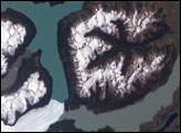
Northwestern Namibia is not your typical desert landscape. Valleys dissect plateaus, creating striking vistas across the hot, dry region in southwest Africa. While these valleys are extremely old—with origins dating back hundreds of millions of years—they are remarkably well preserved.
New research indicates that the valleys are ancient relics of a time long before dinosaurs walked the Earth—when Africa was close to the South Pole, still part of the supercontinent Gondwana, and covered with ice. The flow of the ice cut into the land and eventually carved out long, narrow valleys that filled with seawater and formed fjords. Somehow, these ancient fjords have avoided being erased by erosion, uplift, and other geological processes that usually level off this kind of terrain. In fact, the area is so well preserved that scientists call it a “fossil glacial landscape.”
“One who looks at these valleys has a snapshot of what the fjords looked like 300 million years ago, except that the ice here has long disappeared,” said Pierre Dietrich, a scientist at University of Rennes and lead author of the study published in Geology.
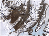
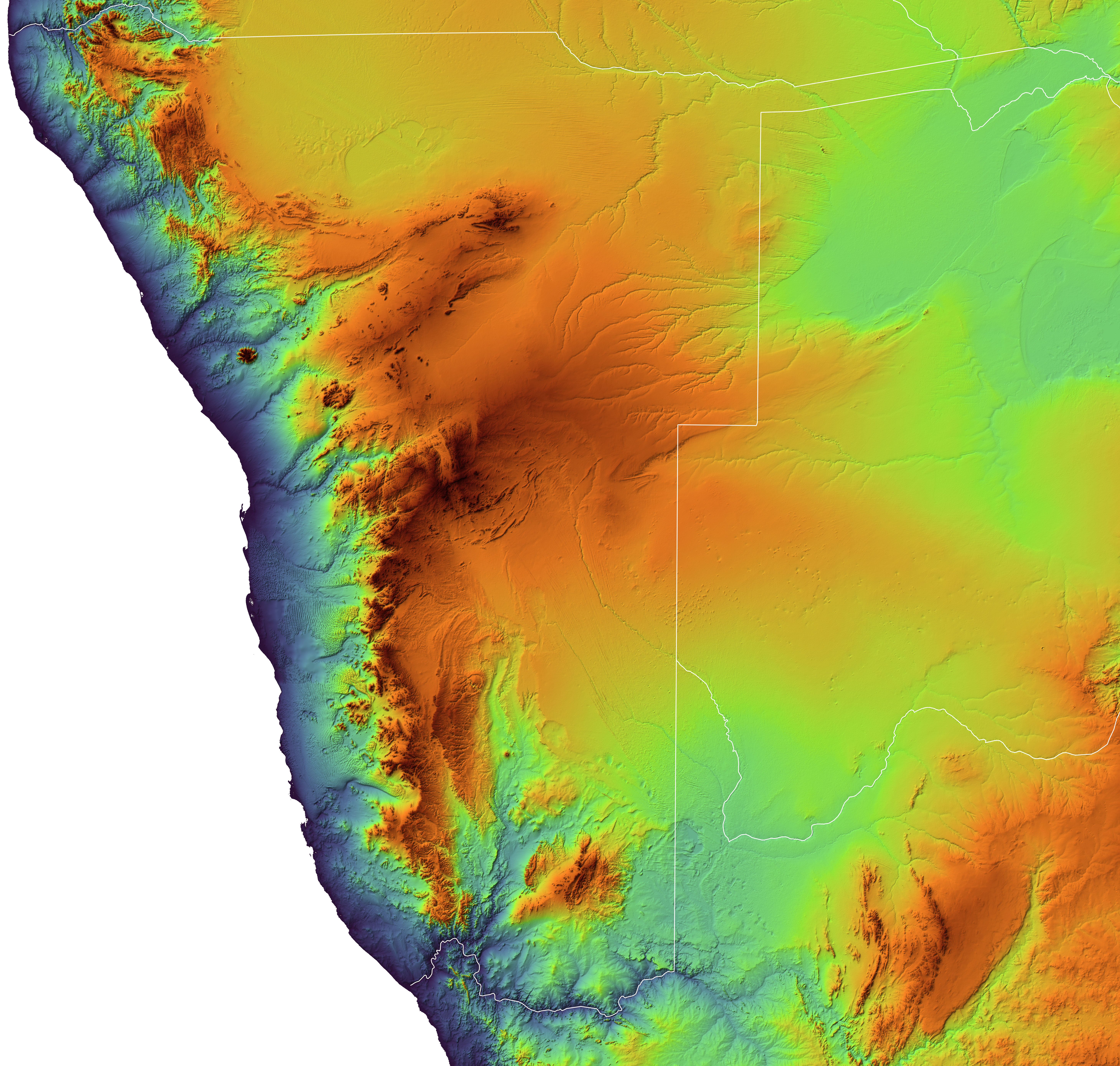
Some of the region’s U-shaped “fossil fjords” (called paleofjords by geologists) are visible in this map, composed from elevation data from the Shuttle Radar Topography Mission (SRTM). The map is false-color to emphasize the topography; red areas are the highest elevations, and blue areas are closer to sea level.
The fossil fjords were carved around 300 million years ago during the Late Paleozoic icehouse, a period when Earth’s climate was cool and Gondwana was heavily glaciated. Today, analogs exist in the ice-carved fjords of Norway and Greenland. Although these modern examples are larger in scale, the land-ice processes are thought to be much the same.
“It was the knowledge of the modern fjord systems that allowed us to interpret the Namibian valleys as paleofjords,” Dietrich said.
Carved under thick flowing ice sheets that later shrank, the valleys still display evidence of their icy past. The researchers found traces of moraines—accumulations of rocks and debris moved by glacial ice—plastered on valley walls. Ice has etched scratches and grooves into the rocks (striae) and in other places sculpted them into rounded knolls (whalebacks).
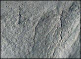
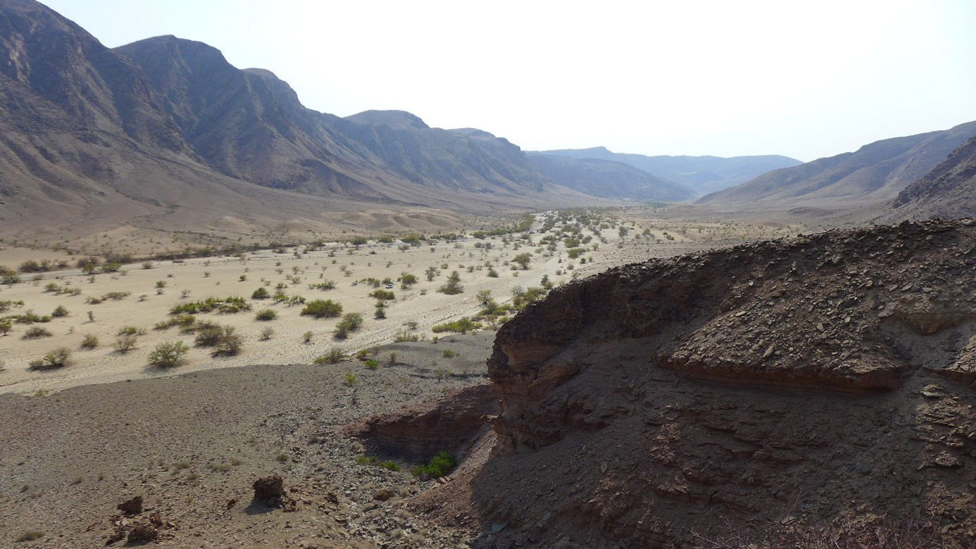
As the glaciers retreated, seawater flowed into the fjords and deposited sediments. Namibia’s fjords slowly filled with more and more sediment, which likely played an important role in preserving them. Erosional processes later began to remove the sediments, leaving behind the stronger rock of the original fjords. The photograph above, shot by Dietrich, shows a close up view of one of the region’s exhumed fossil fjords.
“Nowadays we see the original shape of the fjords as they were when occupied by the ice,” Dietrich said. “The striae looked so fresh and pristine in Namibia that we first thought we had discovered traces of recent glaciers.”
Sediment partly explains why the fjords have been so well preserved, but researchers still want to know how this glacial landscape escaped erosion to such an extreme degree.
“Large-scale glacial landforms such as fjords are usually thought to be transient features, prone to be rapidly erased over geological timescales, which was obviously not the case here,” Dietrich said. “One might therefore ask: what will happen to the fjords of Greenland and Norway in a distant future?”
NASA Earth Observatory image by Joshua Stevens, using topographic data from the Shuttle Radar Topography Mission (SRTM) and information from Dietrich, P. et al. (2021). Photo by Pierre Dietrich/University of Rennes. Story by Kathryn Hansen.