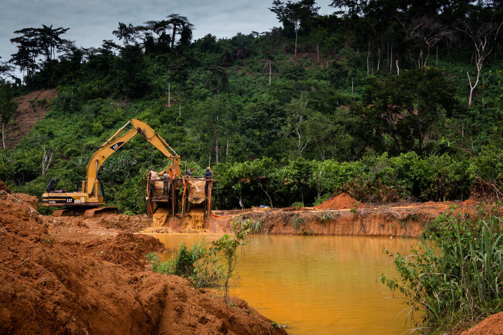
Ghana is one of the leading producers of gold in Africa and the seventh leading producer in the world. Large commercial companies mine the majority of it using heavy machinery. But about 35 percent is extracted through small-scale mines, many of which operate informally or without a valid license.
This unregulated small-scale and artisanal gold mining is known locally as galamsey, a slang word derived from the Ghanaian words “gather” and “sell.” About one million Ghanaians engage in the practice, supporting about 4.5 million people in the country. Many of the galamseyers live in poverty, and their activities often come at a cost to both human health and the environment.
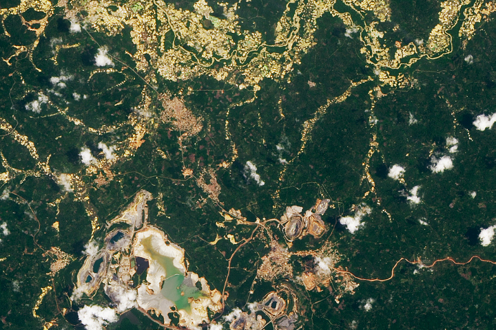
Although individual galamsey sites cover less area than an industrial mine, their cumulative effect on the landscape outweighs those of larger mines. In the southwestern forests of Ghana, for instance, the footprint of small-scale mines is nearly seven times greater than that of industrial mines. The mercury and heavy metals used in galamsey can contaminate drinking water for entire communities. It also causes major health issues, such as kidney problems and neurological disorders, to those continually exposed to the metals.
The Ghanaian government has been increasing law enforcement in recent years related to galamsey activities, but locating the small gold mines is tricky. Many are tucked away in densely forested areas, and some only span a few acres. Unlike larger sites, these mines are usually operated by a few people and sometimes with handheld tools. Unless you knew it was there, the odds of bumping into an artisanal mine are small.
“Local authorities may have knowledge about a specific area, but if the mines are scattered all over the place, then they are difficult to find,” said Foster Mensah, executive director at the Center for Remote Sensing and Geographic Information Services (CERSGIS) in Ghana. “The maps and products we can generate through satellite imagery help them see areas that need attention and intervention.”
Mensah and colleagues at CERSGIS have been working with the SERVIR-West Africa program to identify and quantify mining activities in highly forested areas, which are mostly located in southern Ghana. SERVIR-West Africa is a program between NASA and the U.S. Agency for International Development (USAID) that uses remote sensing to provide support for protection of food and water resources and sustainable development.
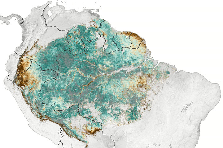
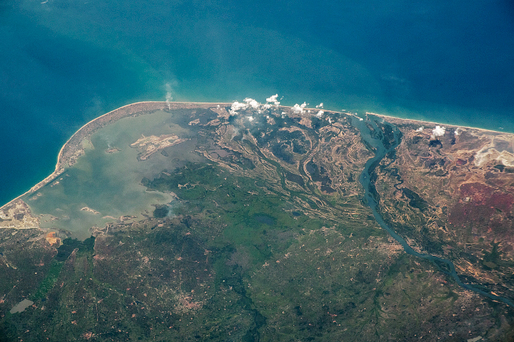
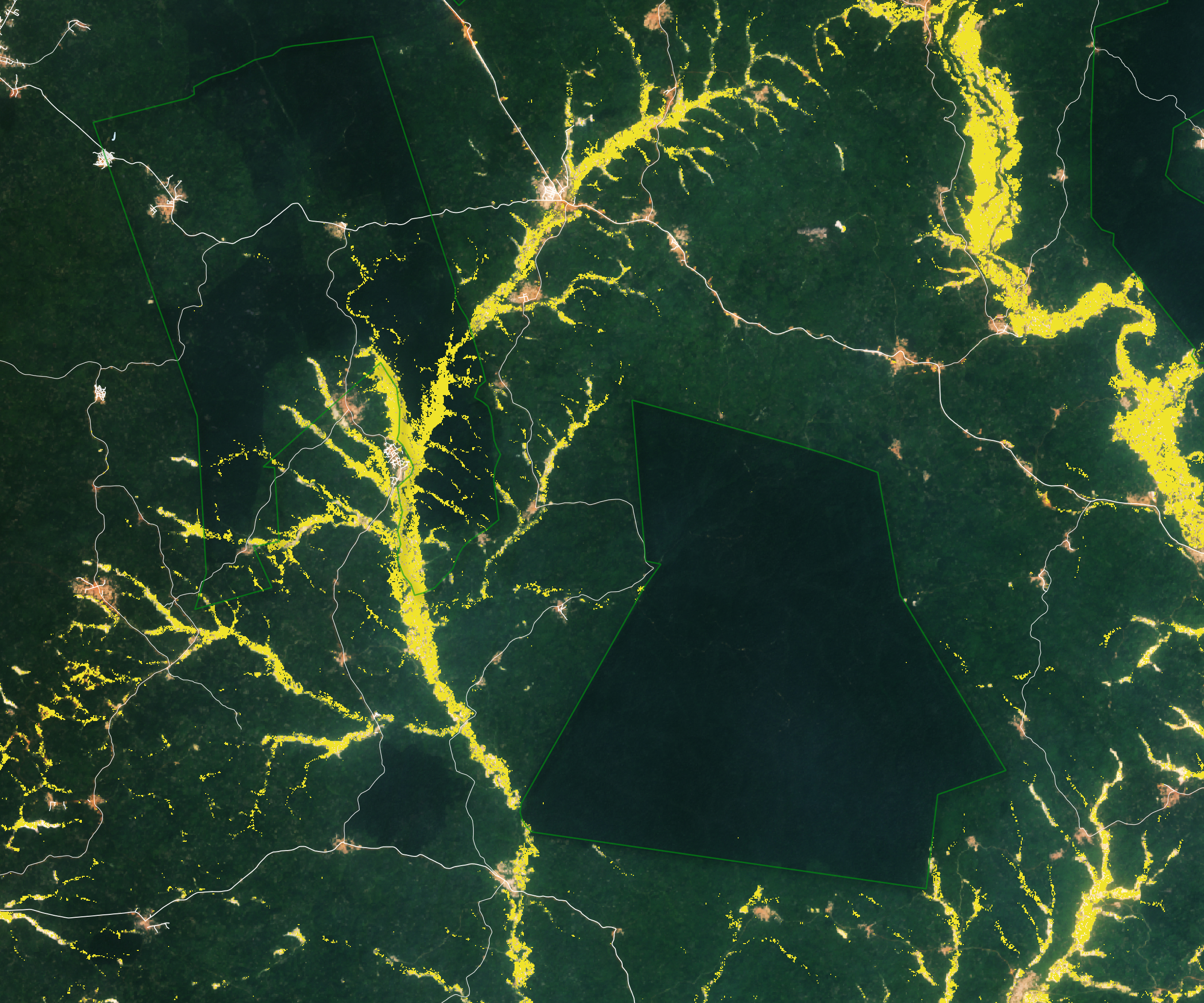
Mensah’s team uses radar data from the European Space Agency’s Sentinel satellites, which can penetrate clouds to see the ground activities below. The team also uses Landsat data to decipher long-term changes in forest coverage and degradation. The visualization at the top of this page shows mining activities from 2015-2020 in southern Ghana. As of 2018, galamsey had led to about 29,000 hectares (72,000 acres) of deforestation, with 1,000 hectares (2,600 acres) occurring in protected areas of the country.
“It can be hard to distinguish between illegal mining and legal mining in an area,” said Mary Amponsah, also a researcher with CERSGIS and SERVIR-West Africa. “When you look at the maps, most illegal activity sits close to legal mining concessions.”
When the government grants legal mining concessions to large companies, Amponsah noted, galamseyers explore the surrounding areas for other places to mine. However, they may not have a license or they may be mining in unauthorized or protected areas. Some license holders also mine more area than allowed.
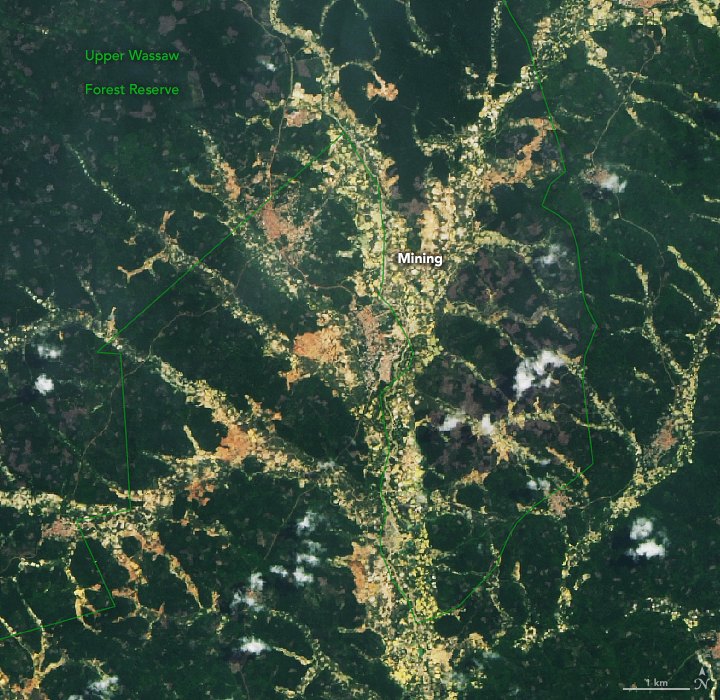
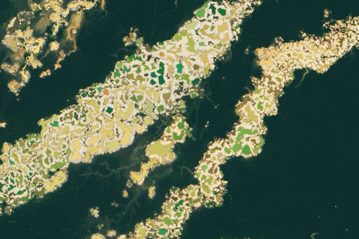
The image above shows gold mining encroachment in the Upper Wassaw Forest Reserve, a habitat for the green-tailed bristlebill and Tai Forest treefrog, which are classified as species of conservation concern. The image was captured on April 30, 2020, by the Operational Land Imager (OLI) on Landsat 8. Out of 28 protected areas in southwestern Ghana, Upper Wassaw had the most mining. As of 2019, about 3.4 percent of the area had been converted for mining activities.
Together with the non-governmental organization A Rocha Ghana, the CERSGIS and SERVIR teams have met with community leaders and showed how galmasey is affecting the landscape and resources. They demonstrated a mobile app that allows anyone to report illegal mining that they see. The satellite data and the crowdsourced information are stored on a web-based portal that the public can access.
The team has also been working with Ghana’s Environmental Protection Agency and its Forestry Commission to highlight areas where mining is affecting forest coverage and degradation. For closed or abandoned mines, the team is also using the satellite data to help inform reclamation projects. Knowing the location and extent of degraded forests can help land managers better project the labor and expense to reclaim an area (by planting tree seedlings or adding plants that could detoxify the area, for instance).
“It boils down to providing authorities information and data they did not have before, especially over a wide area,” said Mensah. “The satellite data is cost effective and gives them a head start on how to pinpoint mining hot spots that need immediate attention.”
NASA Earth Observatory images by Lauren Dauphin, using Landsat data from the U.S. Geological Survey, protected area data from the World Database on Protected Areas (WDPA), and mining data from Center for Remote Sensing and Geographic Information Services (CERSGIS) and SERVIR West Africa. Ground photo by Ruth McDowall. Story by Kasha Patel.