
| The Plain Truth About Floodplains | |||
| "Some hundreds of hundred-year floods occur around the world each year," said Brakenridge. He
explained the severity of a flood is measured by the number of years that pass before a flood of equal
magnitude (having the same amount of discharge) occurs along the same river. Though hundred-year floods are
obviously uncommon for any given river, many of them take place around the globe each year. They vary
greatly in size and can encompass an area as small as a subdivision or as large as the State of Iowa. |
|||
| One of the goals of the Dartmouth team is to map and catalog as many large, hundred-year
floodplains throughout the world as technology permits. Brakenridge said the most precise way to determine
the shape and size of a floodplain is to outline the extent of the water during a flood. By taking images of
floods all around the globe with NASA and National Oceanic and Atmospheric Administration (NOAA) satellites,
the team is able to map more than a hundred floodplains each year. "Ultimately documenting what happens now
gives us the ability to predict which lands will be underwater during future floods," he said. There are many instances where people could have benefited from an accurate record of local floodplains. Last June Brakenridge mapped a flood in west India that wiped out an entire village. A cyclone offshore in the Port of kandla caused the flood. Since cyclones usually come ashore in eastern India, the government and the people living near the port did not know what to expect, he said. When the storm surge hit land, a flash flood engulfed the salt flats just north of the port, killing more than 1,100 people. Brakenridge feels that people in the area would benefit from accurate and available records of this event (Associated Press, June 16, 1998, by Ramola). "Mapping out floods as they occur worldwide may seem like a simple thing to do, but no one else is doing it," said Brakenridge. Many countries do not map floodplains at all. In the United States, maps of hundred-year floodplains do exist, but they are largely inaccurate. The maps are usually made from topographic data and a patchwork of observations and predictions. Often the data are old or the maps are not updated regularly, said Brakenridge. Over a period of decades the elevation of the land around a river changes due to levies, erosion, and construction. The next time that river floods it becomes apparent that the area affected by flooding has changed. "We always superimpose our satellite images of floods on top of these old floodplain maps, and there are some big differences," said Brakenridge. Satellite imaging technology gave Brakenridge's team the ability to monitor any number of floods at once. With support from NASA's Earth Observing System, Brakenridge's EOS Interdisciplinary Science team at Dartmouth constructed more than 200 floodplain maps over 1997 and 1998. To make the maps accessible to the public, they posted a listing of them on their Web site for anyone to order. The most interesting maps can be accessed directly on the Web site along with descriptions of the devastation the flooding caused. Some of the more dramatic flood images from 1998 are those of the Pechora River in Northern Russia. An unusually cold winter caused large amounts of ice to form along the river, which drains into the Barents Sea. When the river began to thaw, huge chunks of ice floated downstream, gathered at the mouth of the river, and formed a dam. The waters backed up for hundreds of kilometers and threatened to pour in on the 35,000 residents in the city of Naryen-Mar. In a last-minute attempt to save the town, the Russian air force brought in four SU-24 assault aircraft and dropped ninety-six 250-kg bombs on the ice, with little effect. Eventually the town had to be evacuated (Associated Press, June 4, 1998).
|
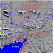
 Red shaded areas on this map (large version) represent areas flooded by a tropical storm that struck land near Kandla, western India. Thousands of people along the coast were killed or driven from their homes by the storm surge, and the salt flats to the north of the city remained inundated with water more than a week after the storm had passed. (Map by E. Anderson and R. Brakenridge, Dartmouth Flood Observatory)
Researchers generate flood maps by comparing satellite imagery from before (June 8, 1998, top) and during (June 14, 1998, bottom) a flood. The additional blue and violet regions of the June 14 image (compared to the June 8 image) indicate flooded lands. (Images by E. Anderson and R. Brakenridge, Dartmouth Flood Observatory) |