
| How to Document a Deluge | ||
| Nearly all the maps on the Dartmouth site are constructed using data from remote sensors like
the Advanced Very High Resolution Radiometer (AVHRR) on the NOAA operational satellites, and the Thematic
Mapper (TM) on NASA’s Landsat 5. Both satellites move in nearly circular obits approximately from pole to
pole around the Earth and measure the infrared and solar radiation from the surface of our revolving planet.
These data are beamed to the surface where scientists like Brakenridge convert them into meaningful images.
While locating floods from these images is easier than mapping them from the ground, the process involves more work than drawing a line around what looks like a flood. The water in the satellite images is frequently sitting under a forest canopy or is mixed in with the soil. "Often times you cannot see the flood [in an image] until you compare it to an image of the land before the flood occurred," said Brakenridge. As anyone who has been caught in a rainstorm knows, dirt, pavement, trees, and clothes all change color slightly when wet. Brakenridge’s team uses this principle to discern flooded land from the dry land. They look for subtle changes in the "before" and "after" pictures of small sections of land known to be flooded and try to find the differences in the colors of light reflected off the land. Once these differences are found, the team highlights areas of the "after" picture that display the change. The researchers then plot the outline of flooded areas in the image onto a map. "The maps are very accurate. We try to provide full resolution image quality," said Brakenridge. The precision of the maps encourages other scientists to incorporate them into their research. Last
October for instance, Robb Jacobson, a research hydrologist at the U. S. Geological Survey (USGS), used
Brakenridge’s 1998 maps of the Missouri River to study flood waters on publicly-owned conservation lands
where levee breaks had occurred. Jacobson said he and other USGS scientists are trying to better
understand how to restore the environment of large rivers and their floodplains. |
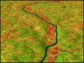
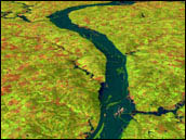
  This pair of Landsat images and animation (combined with elevation data) of Rocheport, Missouri were taken in September 1992 (top) and September 1993 (bottom). Note the brown and pink regions—agricultural fields—along the floodplain that can be seen in 1992, but are submerged in 1993. Floodplains are often fertile because of the sediment deposited there by previous floods. (Images and animation by Jesse Allen, GSFC Visualization Analysis Lab) |
|
Many types of fish spawn in slow-moving, shallow water habitats. In general, these habitats are created when a river overflows its banks during the spring and summer months. However, over the past century levees and embankments have been built all along many of America’s larger rivers, cordoning off many valuable habitats. By observing flooded areas of the Missouri River that no longer have levees, Jacobson and his team are able to measure when, where, and how this habitat is created on natural floodplains. "Dr. Brakenridge’s maps of the levee breaks provide an opportunity to quantify areas inundated by water discharges over broad reaches of the Missouri River," said Jacobson. The information could give the USGS insights on ways to rehabilitate areas in and along these large rivers. Jacobson explained that he is taking advantage of his own research to see how levee breaks affect flooding further down the river. "These [publicly-owned conservation] lands upstream have the potential to store floodwaters, thereby decreasing flood peaks downstream," said Jacobson. By either not repairing or destroying levees on conservation land, state and local governments may someday help prevent floods from hitting populated areas such as St. Louis County and Jefferson City, Missouri. Brakenridge indicated that researchers will find more uses for the maps as knowledge of their existence spreads throughout the scientific community. The maps will probably be particularly helpful in drawing correlations between rainfall and flooding in an area, he said. Developers could also use them to survey an area before buying land. Brakenridge explained that over the next few years he hopes to use the Moderate resolution Imaging Spectroradiometer (MODIS) instrument aboard the Terra satellite to map very large floods at even closer intervals in time. MODIS will return more detailed images than AVHRR, and it will scan the surface of the Earth every two days. The Dartmouth team should be able to turn these data into a global flood map every week. With the way satellite-imaging technology is advancing, satellites could soon monitor any large flood on the globe in real time. "If turnaround time becomes quick enough, we may be able to get images of floods soon enough to alert people," said Brakenridge. |
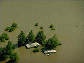
 Flooded houses in Missouri, 1993. Once floodwaters broach or overflow flood control levees, land can stay submerged under standing water for months. (Photograph courtesy Andrea Booher, Federal Emergency Management Agency (FEMA)) |