Two rivers meet near the port city of Santarém in the interior of Brazil.
Published Nov 2, 2015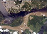
The largest river on the planet, the Amazon, forms from the confluence of the Solimões (the upper Amazon River) and the Negro at the Brazilian city of Manaus in central Amazonas. At the river confluence, the muddy, tan-colored waters of the Solimões meet the “black” water of the Negro River. The unique mixing zone where the waters meet extends downstream through the rainforest for hundreds of kilometers, and is a famous attraction for tourists from all over the world. The tourism contributes to substantial growth in the city of Manaus. Twenty years ago the large park near the city center (center) lay on the eastern outskirts of Manaus.
Published Feb 12, 2005
Corrientes, Argentina (sits on the east bank of the Paraná River, South America’s third largest river. Corrientes is located just inside Argentina, across the river from the southwestern tip of Paraguay.
Published Nov 8, 2004
Alpine in character and perennial in flow, the river is a crucial resource for hydroelectricity, irrigation, transportation, and tourism.
Published Nov 25, 2018
Trees have long been cherished here for timber and for the colors they bring to “the Fall Rhapsody.”
Published Oct 24, 2020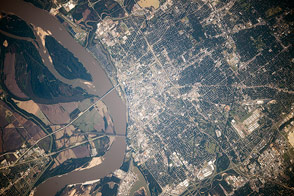
Set on bluffs above the muddy, flood-prone Mississippi River, the city has long been a crossroads of water-borne and land transportation in the heartland of America.
Published Feb 9, 2015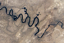
In September 2010, water again flowed through this riverbed after several dry years.
Published Oct 8, 2010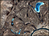
This false-color image from April 1, 2002, shows numerous braided channels and oxbow lakes along the Songhua River in northeastern China, just upstream of the city of Harbin.
Published Dec 27, 2005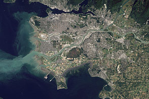
Flowing past the city of Vancouver, the Fraser River delivers a thick plume of sediment to the Strait of Georgia.
Published Mar 14, 2012
Acquired April 2, 2011, and February 27, 2011, these natural-color images show rising waters on the Kuiseb River, which flowed all the way to the Atlantic Ocean for the first time in decades.
Published Apr 12, 2011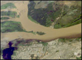
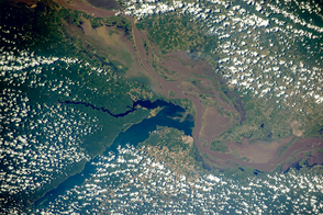
Ciudad Guayana lies on the south bank of the Orinoco River, the second largest in South America, at its confluence with the Caroní River (lower left). Islands have developed in the Orinoco in a wide spot opposite the city (upper left). A low barrage (lower left) dams the Caroní as a water supply for the city. The Orinoco River is a muddy brown, carrying sediment produced by erosion of the Andes Mountains far to the southwest. By contrast, the Caroní is clear blue, as it drains the ancient landscapes of the Guyana Highlands, where erosion is much slower. As at the famous confluence of the muddy Amazon and clear Negro rivers in Amazonia, a mixing zone can be seen in the middle of this image. The clear Caroní water produces a less muddy zone for tens of kilometers downstream of the confluence (this part of the Orinoco flows almost due east, left to right).
Published Jan 23, 2006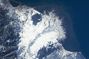
The Selenga River Delta, which stretches out into Russia’s Lake Baikal, is carved by an intricate network of channels and levees and surrounded by marshlands.
Published Nov 28, 2011
alert message
