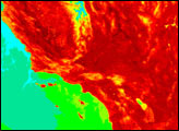

A new study shows heatwaves in Southern California have increased in frequency, duration, and intensity over recent decades.
Published Sep 10, 2020Image of the Day Atmosphere Heat Land Drought Human Presence Remote Sensing Temperature Extremes
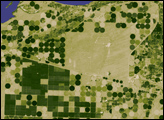
he difference between poplar plantations and native vegetation is illustrated in this pair of satellite images, collected by the Advanced Spaceborne Thermal Emission and Reflection Radiometer (ASTER) on NASA’s Terra satellite on August 27, 2006.
Published Dec 10, 2006
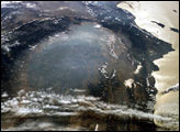
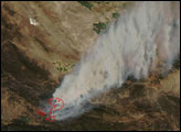
The smoky remnants of October’s devastating fires still filled the southern California Central Valley on November 2, 2003. This “upside down” digital photograph was taken from the International Space Station from a position over the Pacific Northwest looking southward toward southern California. At the time this image was acquired, the fires had finally been brought under control, but ash and smoke remained trapped in the atmosphere above the valley, a bowl of land ringed by the Sierra Nevada Mountains to the east (left) and the Coast Range Mountains to the west (right).
Published Nov 24, 2003alert message
