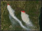

A wildfire in Fresno County, California has burned more than 28,000 acres.
Published Jul 20, 2020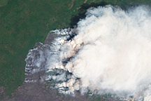
The plumes of smoke billowing into the sky represent the greatest danger the Honey Prairie Fire posed on May 8, 2011, when the Landsat-7 satellite captured this image.
Published May 10, 2011
This image from June 9, 2011, shows Arizona’s Wallow Fire in the White Mountains near the border with New Mexico.
Published Jun 10, 2011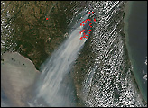

The blaze is the largest in Arizona this year and the largest in the United States right now.
Published Jun 16, 2020Image of the Day Heat Land Fires Human Presence Remote Sensing
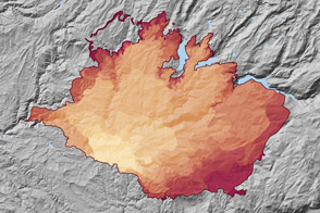
At 369 square miles in size, the Rim Fire is the largest in the United States in 2013.
Published Sep 4, 2013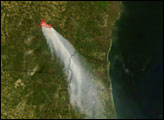
alert message
