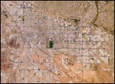
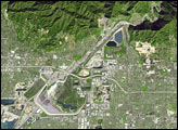
Tucson lies between the forested Catalina Mountains and the Tucson Mountains (dark reddish brown at the left image margin).The typical western North American cityscape is a pattern of regular north-south aligned rectangles outlined by major streets set one mile apart.
Published Jul 19, 2004
This hand-held astronaut photo shows urban areas and fault-related topographic features from San Bernardino, California, to Tijuana, Mexico.
Published Dec 15, 2008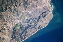
This detailed astronaut photograph highlights the Santa Barbara, California, metropolitan area, sometimes called the “American Riviera.”
Published Feb 9, 2009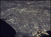
In this image, an astronaut photograph of the Los Angeles area is overlaid on a topographic image made from the United States Geological Survey National Elevation Dataset (1 arcsecond resolution). The grid of streets is outlined by orange (sodium vapor) and blue-green (mercury vapor) lights. The airport, the naval docks, and downtown LA are especially bright.
Published May 1, 2008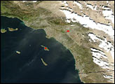
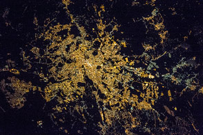
The radial pattern of highways echoes the ancient saying that “all roads lead to Rome.”
Published Jul 28, 2016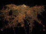
Buenos Aires is one of the larger cities seen by orbiting crews. Twelve million people, almost one third of all Argentines, live in this city, often called the “Paris of the South”.
Published Mar 16, 2003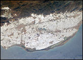
The sunny south of Spain offers more to the national economy than simply tourism. Over the past 50 years, the small coastal plain (campo), some 30 kilometers southwest of the city of Almería, has been intensively developed for agriculture. An estimated 20,000 hecatres of extra-early market produce is grown in greenhouses in the Campo de Dalías.
Published May 24, 2004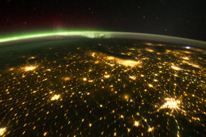
When viewed from the International Space Station, the night skies are illuminated with light from many sources.
Published Oct 24, 2011alert message
