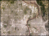
The Missouri River served as a vital waterway for transport of the epic Lewis and Clark Expedition. In the vicinity of Omaha, Nebraska, and Council Bluffs, Iowa, this mighty river meanders southward through a broad floodplain some two to eight miles wide, bordered by dissected bluffs. In late July 1804, the expedition paused to rest and repair their boats and planned the “first” Native American council (Council Bluff) with representatives of the Otoe Tribe.
Published Jun 22, 2003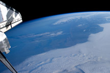
This sequence of time-lapse photographs illustrates roughly half an orbit of the International Space Station, from Northern Europe to Australia.
Published Jun 28, 2010
This image represents, for its time, the greatest detail of the Giza plateau captured from a human-occupied spacecraft.
Published Oct 14, 2001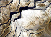
This detailed image of Everest, the highest (29,035 feet, 8850 meters) mountain in the world, shows early morning light on the eastern Kangshung Face. The mountains appear to jump out of the picture because the image was taken with low sunlight using an electronic still camera equipped with an 800 mm lens.
Published Apr 28, 2002
As NASA's latest care package heads toward the International Space Station, it traveled over beautiful Earth landscapes—from scenic snowscapes to desolate deserts.
Published Dec 21, 2018
The colors of the agricultural fields surrounding Paris are striking in thespringtime, even when viewed from a 400-kilometer orbital altitude, as seen in this photography taken by astronauts on board the International Space Station.
Published May 12, 2002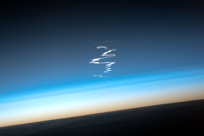
Exhaust trails mark the flight of a Soyuz rocket that delivered crew members to the International Space Station.
Published Oct 26, 2012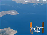
An astronaut shot this photograph while looking back across the length of Endeavour.
Published Sep 24, 2007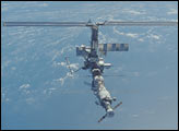
The above photo of the International Space Station was taken by an astronaut aboard the space shuttle on April 17, 2002. Although its construction is not yet complete, Space Station Alpha began operations in November 2000. It now serves as home to three astronauts as well as dozens of already ongoing science experiments.
Published Jan 25, 2003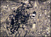
A series of digital photographs of Houston illustrates the new detail being obtained for cities around the world by crewmembers on the International Space Station. This image, captured on 17 December 2000 centers on the downtown region and shows extensive detail of streets, parks and major buildings.
Published Jun 3, 2001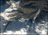
While docked to the Space Station the international crew of Space Shuttle Mission STS-112 paused as the spacecraft sped over the Caucasus Range. They had planned before launch that a crewmember would look out the windows of the spacecraft for remnants of the disastrous collapse of Kolka Glacier. The close collaboration between the USA and Russia on all aspects of Space Station construction, and the presence on the Shuttle crew of Russian mission specialist Fyodor Yurchikhin, made the crew particularly interested in photographing the area to help scientists on the ground in their studies of the collapse. There is a dramatic difference between this digital photograph taken by the Shuttle crew and one taken just a week before the collapse by the International Space Station crew.
Published Oct 27, 2002alert message
