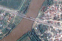
The day after a powerful 7.3-magnitude earthquake shook Honduras, Taiwan’s Formosat-2 satellite captured this detailed, photo-like image showing the collapsed span of the earthquake-damaged Democracy bridge.
Published Jun 3, 2009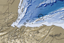
This image shows the topography and bathymetry of the region surrounding the earthquakes that occurred on May 28-29, 2009. Red circles indicate quake locations, and fine black lines indicate fault lines.
Published May 30, 2009