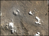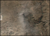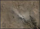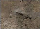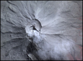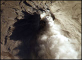
Subduction of the Nazca tectonic plate along the western coast of South America forms the high Peruvian Andes. The subduction (movement of one plate beneath another) also produces magma, feeding a chain of historically active volcanoes along the western front of the mountains. The most active of these volcanoes in Peru is Ubinas. A typical, steep-sided stratovolcano comprised primarily of layers of silica-rich lava flows, it has a summit elevation of 5,672 meters (18,609 feet). At 1.4 kilometers (0.87 miles) across, the volcano’s caldera gives it a truncated profile. Hardened lava flows from past eruptions linger on the volcano’s flanks. This oblique image (looking at an angle) from the International Space Station (ISS) captures an ash cloud first observed on satellite imagery at 11:00 GMT on August 14, 2006. An ISS astronaut took this picture one hour and 45 minutes later.
Published Aug 21, 2006