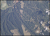
Forests are being harvested near Tokoroa, New Zealand, which has been described as the hub of New Zealand’s forestry industry. The large tan areas are cleared forests. The land use pattern that looks like tan beads on a string are clearings used to stock timber before it is sent to pulp and paper mills about 4 kilometers south of Tokoroa. The light green areas around the town are dairy farms.
Published Jun 16, 2002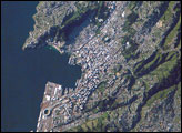
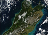
New Zealand’s capital, Wellington, sits at the southwestern tip of North Island near the Cook Strait. The city in the second largest in New Zealand (after Auckland), and at 41 south latitude, it is the southernmost capital city in the world. The North and South Islands of New Zealand are located along the active Australian-Pacific tectonic plate boundary. The glancing collision of these two tectonic plates results in uplift of the land surface, expressed as low hills on North Island and the Southern Alps on South Island.
Published Dec 9, 2007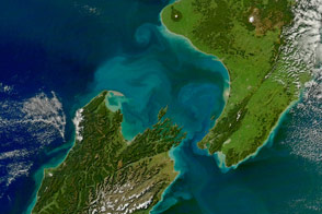
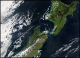
Sediment and phytoplankton create bright swirls of color in this image of New Zealand taken on April 29, 2011.
Published May 26, 2011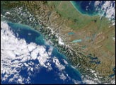
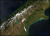
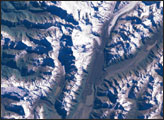
Colors ranging from deep brown to stark white give New Zealand’s South Island its intense beauty. The snow-capped Southern Alps run down the northern shore of the island. The mountains are rising as the Pacific Plate, the section of the Earth’s crust that holds the Pacific Ocean, including parts of New Zealand’s South Island, sinks beneath the Australia Plate, which holds the rest of New Zealand.
Published Dec 22, 2007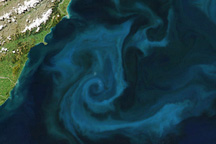
A phytoplankton bloom colored the waters east of New Zealand on October 25, 2009.
Published Oct 28, 2009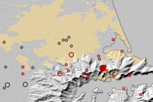
This map shows the location of earthquakes on near Christchurch, New Zealand between September 3, 2010, and February 22, 2011.
Published Feb 23, 2011