
CloudSat captured a vertical slice of the potent storm on July 5.
Published Jul 8, 2014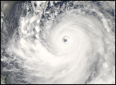
Though Typhoon Choi-wan maintains its tightly wound symmetric shape in this photo-like image from September 18, 2009, the striking clear eye of previous days is gone.
Published Sep 18, 2009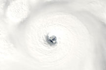
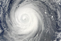
Acquired November 25, 2009, this true-color image shows Typhoon Nida near the island of Guam. High-profile clouds circle a well-formed eye at the center of the storm.
Published Nov 25, 2009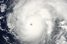
Typhoon Vamco has a small, distinctive eye defined by a wall of clouds in this photo-like image from August 20, 2009.
Published Aug 20, 2009
A radar on CloudSat imaged the internal structure of a powerful typhoon that will likely skirt east of Japan in the coming days.
Published Aug 21, 2015
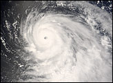
The powerful, well developed storm spins over the western tropical Pacific Ocean.
Published Aug 1, 2017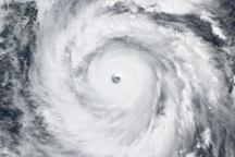
Seen from space, even a super typhoon seems more beautiful than dangerous. This image of a graceful-looking Typhoon Jangmi was captured on September 27, 2008, as the storm approached Taiwan.
Published Aug 28, 2009
These photo-like and radar images together show the structure of the Category 1 Hurricane Jimena shortly after it make landfall over Baja California on September 2, 2009.
Published Sep 5, 2009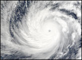
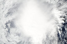
Acquired December 2, 2009, this true-color image shows Nida, now weakened to a tropical storm. The storm lacks a distinct eye, but does extend long tendrils toward the southwest.
Published Dec 2, 2009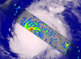
Typhoon Nakri was swirling in the western Pacific Ocean as a powerful Category 4 storm when the Moderate Resolution Imaging Spectroradiometer (MODIS) on NASA’s Terra satellite viewed it on May 29, 2008.
Published May 29, 2008