
Less than a year after getting hit by Hurricane Harvey, southern Texas was again struck by torrential rains and flash floods. Several days of heavy rainfall submerged coastal cities under several inches of water. Some roads crumbled, creating massive sinkholes. Fish were seen swimming in the streets. Local governments made “state of disaster” declarations.
The heavy rain came from a low-pressure system that traveled from the northwestern Caribbean. It continued toward the southern Gulf of Mexico as a disorganized mass of showers and thunderstorms. The slow–moving system never evolved into a hurricane or tropical storm, but the gusty winds dropped rainfall at rates normally found in such storms.
The map shows rainfall accumulation over southeast Texas from June 18 at 7 a.m. Central Daylight Time to June 21 at 7 a.m. These rainfall data are remotely-sensed estimates that come from the Integrated Multi-Satellite Retrievals (IMERG), a product of the Global Precipitation Measurement (GPM) mission. The GPM satellite is the core of a rainfall observatory that includes measurements from NASA, the Japan Aerospace Exploration Agency, and five other national and international partners. Local rainfall amounts can be significantly higher when measured from the ground.
Water levels in Brownsville were high enough to submerge cars and houses. Rain also soaked Victoria and Corpus Christi, which received around 20 inches (500 mm) of rain in just 72 hours, according to the National Weather Service. The storm grazed Houston but lingered over the Beaumont and Port Arthur areas, which also received nearly a foot of water.

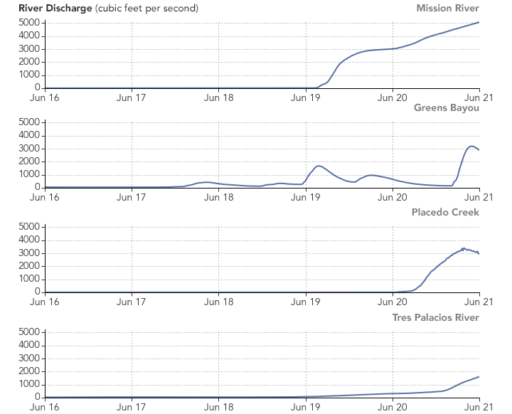
The storms’ effects are also apparent through the increase in river discharge by local streams. Mission River near Corpus Christi showed a fairly steady increase in river discharge starting on June 20. Placedo Creek saw an extraordinary river discharge at 400 times the norm.The data were provided by U.S. Geological Survey Water Resources.
Skies are expected to clear up in the coming days, but flooding damage will remain. The event was particularly traumatizing to the coastal residents, who are still rebuilding from Hurricane Harvey.
NASA Earth Observatory images by Joshua Stevens, using IMERG data from the Global Precipitation Mission (GPM) at NASA/GSFC and National Water Information System data from the U.S. Geological Survey. Story by Kasha Patel.