

When the builders of Camp Century began storing waste in Greenland’s ice sheet, they had every reason to rest easy. Snow and ice would continue to accumulate, sealing the Cold War military base in an icy tomb—or so they thought. But the builders failed to foresee that one day, those frigid layers could instead start melting.
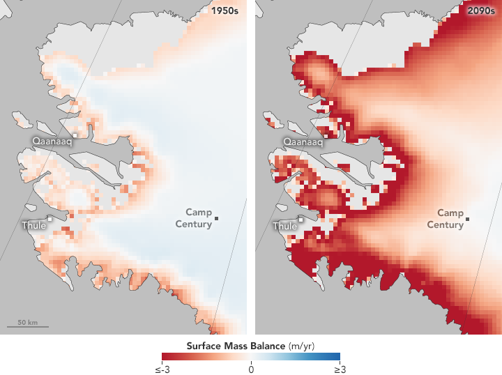
A 2016 study published in Geophysical Research Letters suggests that by the end of the 21st Century, the scale could tilt in the favor of ice loss instead of buildup. The crust of snow and ice above the former base could begin to melt away by the end of the century, eventually leading to the exposure of waste that has been buried for decades. If net ablation—the thinning of ice due to evaporation, melting, and wind—occurs, the ice will cease to be a reliable repository.
The maps above show changes in surface mass balance—the net change between the accumulation and ablation of ice and snow on a glacier’s surface. Deeper red areas signify places where the ice surface is likely to drop by three or more meters (10 feet) per year. Blue areas indicate slight net gains in ice cover; white indicates no change. The pale pink area around Camp Century suggests that by 2090 or so, the area would start to see ice losses.
The study authors estimated that the Camp Century site contains 200,000 liters (53,000 gallons) of diesel fuel and 24,000,000 liters (6,340,000 gallons) of wastewater, including sewage. It contains an unknown quantity of low-level radioactive waste and polychlorinated biphenyls (PCBs). Liquid meltwater could carry PCBs deeper into the ice—and farther downhill—long before surface melting occurs, according to the study.
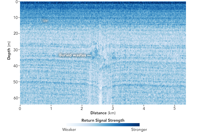
The image below is a radar profile acquired on May 2, 2011, by airborne instruments deployed as part of NASA’s Operation IceBridge. Disturbances in the smooth ice layering “indicate the presence of buried physical wastes at depths consistent with those predicted for the Camp Century tunnels,” the study authors wrote. The solid waste buried roughly 30 meters (100 feet) below the ice surface is visible in radar images and appears darker in the image.
Because it is not far from the edge of the retreating Greenland Ice Sheet, Camp Century could be exposed if nothing is done to curb global warming, said the study’s lead author, William Colgan. Right away people start to jump to the conclusion: “How are we going to adapt to this and start talking about what to do in 2090,” he said. “This is just one in a very long list of reasons to say: how do we try and mitigate climate change now?”

NASA Earth Observatory images by Jesse Allen, using IceBridge UHF ice-penetrating radar data provided by Joseph MacGregor (NASA/GSFC) and surface balance model data by William Colgan (York University). Caption by Pola Lem.
Image of the Day Heat Human Presence Snow and Ice Remote Sensing
By 2090, the scale could tilt in the favor of ice loss instead of buildup.
Image of the Day for January 31, 2017