

Long before satellites captured images of the Delaware Water Gap, artist George Inness captured the sense of the place in his 1861 oil painting by the same title. It would be one of many landscapes of the area he would paint in subsequent decades.
In the 1800s, the Delaware River was a busy thruway. By the time Inness painted it, the Gap was already a destination for vacationers, due in part to its proximity to New York City just 80 miles (130 kilometers) away. With the completion of the Kittatinny Hotel in 1832, a resort industry began there. In addition to steamships on the river, new railroads began carrying passengers to the area. By the end of the Civil War, the Kittatinny’s 25-guest capacity would grow to more than 250. At the turn of the 20th century, the Gap would include 16 major hotels.
Even as automobiles replaced trains, the spot remained popular. Youth camps sprang up along the Delaware River in the early 1900s. Between 1928 and 1972, roughly 250,000 Boy Scouts set up tents along its shores, according to National Park Service figures.
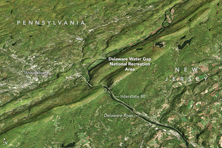
The Operational Land Imager (OLI) on the Landsat 8 satellite acquired this image of the Delaware Water Gap on October 15, 2016. The Landsat image was combined with terrain data from the Advanced Spaceborne Thermal Emission and Reflection Radiometer, ASTER.
Today, the Delaware Water Gap National Recreation Area draws hikers and birders; kayakers have replaced the steamboats of yore. The recreation area includes 67,000 acres (270 square kilometers) of mountainous terrain and floodplain.
This year is the 100th anniversary of the National Park Service. We are celebrating this milestone with a gallery of images that you can see here.
NASA Earth Observatory image by Jesse Allen, using Landsat data from the U.S. Geological Survey and ASTER GDEM2 data from NASA/GSFC/METI/ERSDAC/JAROS, and U.S./Japan ASTER Science Team. Caption by Pola Lem.