

Triggered by seasonal changes in available sunlight, about 50 million square kilometers of the Earth’s land surface undergo a transition from freeze to thaw each year. Snow and ice disappear then return, frozen ground softens and hardens, vegetation “greens up” and fades. Satellite sensors can detect many of these processes through seasonal changes in the amount of sunlight reflected by the Earth’s surface at various wavelengths. The percentage of light that a surface reflects out of the total light falling on it is the surface’s albedo. Bright, reflective surfaces, such as fresh snow, have a high albedo; dark, absorptive surfaces, such as dense forest, have a low albedo.
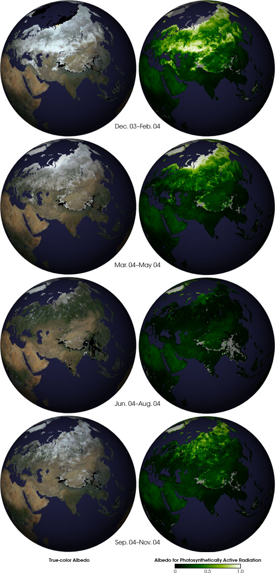
These globes display seasonal albedo observations over much of Asia collected by NASA’s Multi-angle Imaging SpectroRadiometer (MISR) in 2004. The left-hand column of globes is natural-color, made by combining MISR-observed albedos in a way that is similar to what our eyes would see. The right-hand set of globes shows the albedo for only the wavelengths of light that plants use for photosynthesis or the albedo for Photosynthetically Active Radiation (PAR). Places where the surface is reflecting most of the photosynthetic wavelengths (high albedo) are off-white or tan; places where the surface is absorbing most of the photosynthetic wavelengths (low albedo) are dark green to nearly black. Gray areas indicate lack of data, for example, because of persistent cloudiness. Particles in the atmosphere can interfere with the collection of surface-albedo measurements because the particles scatter incoming sunlight in all directions; however, all the scattering effects from the atmosphere have been removed from these albedo globes.
In December through February, snow covers the northern latitudes, making the land surface more reflective, and therefore increasing the albedo. The albedo in photosynthetically active wavelengths is also high (white, tan, and yellow values) because it is winter, and plants are not very active. As the seasons progress, the albedo in photosynthetically active wavelengths of light decreases because plants are abundant and active; by the June-through-August period, vegetation across Asia was absorbing almost all of the photosynthetic light coming in from the Sun. Areas with higher albedos even during the summer growing season include the semi-arid Tibetan Plateau (roughly centered in the globes), the Arabian Peninsula (far left), and the high Arctic (top).
For more detail and additional globes, visit the MISR image page. For MISR’s five-year, global albedo data record, and for other surface and vegetation products from the MISR instrument, visit the NASA-Langley Atmospheric Sciences Data Center’s MISR Level 3 Imagery Website.
The Multi-angle Imaging SpectroRadiometer observes the daylit Earth continuously from pole to pole, and every 9 days views the entire globe between 82 degrees north and 82 degrees south latitude. MISR was built and is managed by NASA's Jet Propulsion Laboratory, Pasadena, CA, for NASA's Office of Earth Science, Washington, DC. The Terra satellite is managed by NASA's Goddard Space Flight Center, Greenbelt, MD. JPL is a division of the California Institute of Technology.
Image courtesy NASA/GSFC/LaRC/JPL, MISR Team. Text by John Martonchik (JPL) and Clare Averill (Raytheon ITSS/JPL).