
At 00:58:53 UTC (Coordinated Universal Time) on December 26, 2004, a magnitude 9.0 earthquake occurred off the west coast of Sumatra, Indonesia. This was the fourth largest earthquake in the world since 1900 and the largest in over 40 years. It is estimated that the sea floor was displaced several meters due to the quake, resulting in large ocean waves, called “tsunamis” from the Japanese for “harbor waves.” The tsunamis moved rapidly across the deep ocean, with speeds estimated around 640 kilometers per hour. When the waves reach shallow water near land, they slow considerably, but their size increases dramatically. They strike with catastrophic force. With human casualties exceeding 200,000, this event is one of the deadliest natural disasters in modern history, causing devastation along the shores of Indonesia, Sri Lanka, India, Thailand, and other countries.
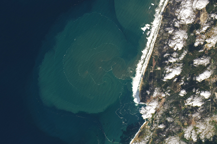
The initial tsunamis reached the eastern Indian coast around 3:35 UTC, based on tide-gauge measurements made at the port city of Vishakapatnam. The Multi-angle Imaging SpectroRadiometer (MISR) aboard NASA’s Terra satellite passed over the eastern Indian coast between 5:10 to 5:20 UTC, when the tide gauge indicated the arrival of another series of waves. Because MISR’s nine cameras imaged the coast over a time span of about 7 minutes, and because the waves are unusually large, MISR was able to capture unique time-lapse imagery of the breaking waves. The image shows four frames from the instrument’s backward-viewing cameras spanning a period of about 2.5 minutes. This scene is located along the shores of Andhra Pradesh, near the mouth of the Godavari River, and covers an area of 42 kilometers by 37 kilometers. The arrows show the progression of the southwestern edges of the breakers.
A series of frames spanning nearly 6 minutes has been made into a small animated GIF (588 kB). An animated GIF (5.8 MB) covering a somewhat larger area of 86 kilometers by 49 kilometers is also available. A second animated GIF (3.8 MB) shows a region farther south, at the northern end of India’s Coromandel Coast, and covers an area of 43 kilometers by 58 kilometers. Cloud “motion” in these animations results from apparent displacements due to parallax associated with the clouds’ height above the surface. The tsunami waves, on the other hand, are at sea level and show actual motion. When the waves arrive in the shallower water near the shore, they grow and, if they become large enough, they will break in a manner similar to typical oceanic waves, but on a much larger scale. The leading edge of the breaking waves is likely what is visible in the imagery. Additionally, if the tsunami waves strike the coast at an angle, they can produce what are known as “edge waves,” which propagate parallel to the coast. There is clear evidence of edge-wave generation in these images.
Upon discovering the unique content of this imagery, MISR scientists contacted Dr. Vasily Titov at the National Oceanic and Atmospheric Administration’s Pacific Marine Environmental Laboratory in Seattle, WA. Dr. Titov is an expert in the propagation of tsunamis, and has generated a model animation of the tsunami’s progression from its origin near Sumatra. The MISR imagery provides measurements of the location and timing of the breaking waves, their angle relative to the shoreline, and their speed of propagation, which is estimated from these data to be around 30 kilometers per hour. In conjunction with bathymetric measurements of ocean depth, this information can be used to refine and calibrate tsunami propagation models. According to Dr. Titov, improving these models has two primary benefits. First, a detailed understanding of wave interactions with coastal areas is necessary for developing damage-mitigation approaches. Second, a better predictive capability will make possible more accurate near-real-time forecasts of tsunami arrival times and effects.
NASA image courtesy NASA/GSFC/LaRC/JPL, MISR Team. Text by Michael Garay and David J. Diner (JPL, California Institute of Technology); Clare Averill (Raytheon ITSS/ JPL); Vasily Titov (NOAA Pacific Marine Environmental Laboratory)
alert message


