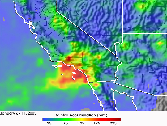


Day after day of stormy weather has lead to flooding, mudslides and huge snowfall totals across California. Well over 10 feet of snow has fallen across much of the Sierra Nevada, and over 2 feet of rain was reported in the San Gabriel Mountains northeast of Los Angeles. To blame is the steady stream of moisture being brought up from the subtropics from near Hawaii by the subtropical jet steam known as the “Pineapple Express.” The Pineapple Express can also interact with storm systems rotating around a large, persistent upper-level low-pressure system off the West Coast, as in the current situation. Additionally, mountainous topography is effective in squeezing out even more moisture in the form of steady precipitation as the warm, moisture-laden air rides up and over the slopes.
The TRMM-based, near-real-time Multi-satellite Precipitation Analysis (MPA) at NASA’s Goddard Space Flight Center monitors rainfall over the global Tropics. Here MPA rainfall totals are shown for the period from January 6 - 11, 2005. The red areas just off of the coast indicate the highest totals of more than 225 mm (about 9 inches) of rainfall. Coastal areas of southern California including Los Angeles and San Diego generally received between 4 and 7 inches of rain (orange areas) for the period.
TRMM is a joint mission between NASA and the Japanese space agency JAXA.
Image and animations produced by Hal Pierce (SSAI/NASA GSFC) and caption by Steve Lang (SSAI/NASA GSFC).