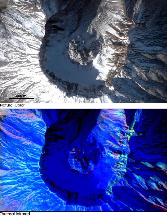


After more than a decade of inactivity, Mount St. Helens rumbled back to life in September 2004. An ongoing series of tremors within the volcano coupled with upward movement of magma toward its caldera prompted geologists to issue a Level 3 alert on October 2, stating that Mount St. Helens could experience a moderately severe eruption at any time.
In order to help geologists and vulcanologists assess the nature and magnitude of the risk, on September 24, 2004, NASA flew a low-altitude aircraft carrying the MODIS/ASTER Airborne Simulator (MASTER) directly over the volcano to obtain high-resolution images of its caldera. The images above show the caldera in spectacular detail; the high-resolution copies also available above have a spatial resolution of 3 meters per pixel. The top image shows Mount St. Helens in natural color while the bottom scene was produced using MASTER’s thermal infrared detectors. The bulge in the center of the volcano’s caldera is the lava dome, which has been growing in size in recent weeks due to the upward pressure of magma within the volcano. The red-orange patches show where heat is venting from the lava dome.
After these images were obtained, Mount St. Helens has emitted several plumes of ash and steam, as if to validate geologists’ warning that it could erupt at any time. However, on October 6, geologists lowered the volcano’s alert level and even though the threat of an eruption appears to be subsiding they cautioned that “episodic changes in level of unrest over periods of days to weeks, or even months, are possible.”
NASA images courtesy Jeff Myers and Rose Dominguez, MASTER Project, Ames Research Center and the Jet Propulsion Laboratory