The Earth Observatory has published its last Image of the Day on this website. Please join us on our new home at science.nasa.gov/earth/earth-observatory.

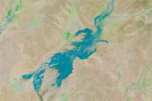
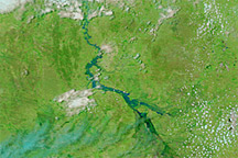
Levees along the Warrego River kept the town of Cunnamulla dry in early March 2010, according to a report in The Sydney Morning Herald. With or without levees, the swelling along the waterways in Australian Channel Country was obvious in satellite imagery. The region is characterized by impermanent rivers that arise from infrequent rains.
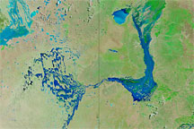
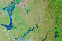
The Moderate Resolution Imaging Spectroradiometer (MODIS) on NASA’s Aqua satellite captured these images of southwestern Queensland on March 8, 2010 (top), and February 23, 2010 (bottom). These images use a combination of infrared and visible light to increase the contrast between water and land. Vegetation, even sparse vegetation, appears bright green. Clouds appear sky blue. Water varies in color from electric blue to navy. Bare ground appears tan.
In the image acquired in March, floodwaters surge through waterways that appear much smaller or completely dry in the image from late February. The Paroo and Bulloo Rivers swell conspicuously between February and March. At the same time, the Warrego River, closest to the town of Cunnamulla, appears to fill what was a dry river channel just weeks earlier.
Although levees protected Cunnamulla, other settlements in southwestern Queensland, including St. George and Theodore (not pictured), were either flooded or at risk of flooding as nearby rivers rose.
NASA image courtesy MODIS Rapid Response Team at NASA GSFC. Caption by Michon Scott.