

Just south of the vast expanse of the Sahara desert, a belt of fertile grassland stretches across the bulge of Africa. Called the Sahel, the region thrives or fails depending on seasonal rainfall, which comes primarily in a handful of weeks during the rainy season. In dry years, little grows, and those who depend on rain to grow crops in the Sahel may face hunger. In wet years, crops grow well, providing a source of income and food for people in many countries. In 2009, the outlook was not good for plants in the Sahel.
This series of images shows how little rain fell during the long rainy season in 2009 and how plants responded. The top image, made from data collected by the Advanced Very High Resolution Radiometer (AVHRR) flying on the National Oceanic and Atmospheric Administration’s Polar Orbiting Environmental Satellite NOAA-17, shows the condition of plants in June 2009 compared to previous Junes. In areas that are brown, plants were growing less then they had on average between 2003 and 2008. Green areas indicate better-than-average growth, while cream-colored areas are regions where growth was about average. A strip of brown lines the top of the Sahel and extends down through East Africa.
The poor growth in June 2009 is the result of a weak rainy season. Seasonal rains, which usually come between March and June, were insubstantial in 2009, resulting in drought. Made from a combination of satellite and rain gauge measurements, the middle image shows the extent of the rainfall deficit between March and June. Areas that are brown received less rain than average, while blue areas received more rain. The average was calculated from rainfall observed between March and June from 1995 through 2008. The northern Sahel and East Africa were drier than normal throughout the 2009 rainy season.
The drought caused food and water shortages in Kenya. The country entered a state of emergency when approximately 10 million people, a third of the country’s population, needed food aid, reported Reuters. The poor rains also led to water and power shortages as reservoirs dried up. According to local news, cities throughout Kenya rationed water when municipal supplies fell short. The Kenya Electricity Generating Company closed the Masinga hydroelectric dam after water levels in the reservoir fell too much to sustain power generation, reported BBC News on July 1, 2009.
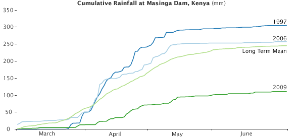
The graph illustrates why water levels were so low at Masinga Dam in 2009 compared to the long-term average and other recent years. Each line shows how the rainy season developed between March and June. It 1997, it was unusually wet, with about 75 millimeters more rain than average by the end of June. The last year when rainfall reached normal levels was 2006. In 2009, the rainy season didn’t start until late March and less rain fell throughout the season. By the end of June, Masinga Dam had only received about 100 millimeters of rain, about 125 mm less than average and 200 mm less than in 1997. If conditions improve, Kenya’s next rainy season will likely begin in September or October and will last through November or December.
Images created by Jesse Allen, using GIMMS NOAA-17 AVHRR and Africa Rainfall Estimate data provided by Ed Pak, Jennifer Small and Assaf Anyamba, NASA GIMMS Group at Goddard Space Flight Center. Caption by Holli Riebeek with information from Assaf Anyamba.