The Earth Observatory has published its last Image of the Day on this website. Please join us on our new home at science.nasa.gov/earth/earth-observatory.
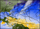
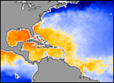
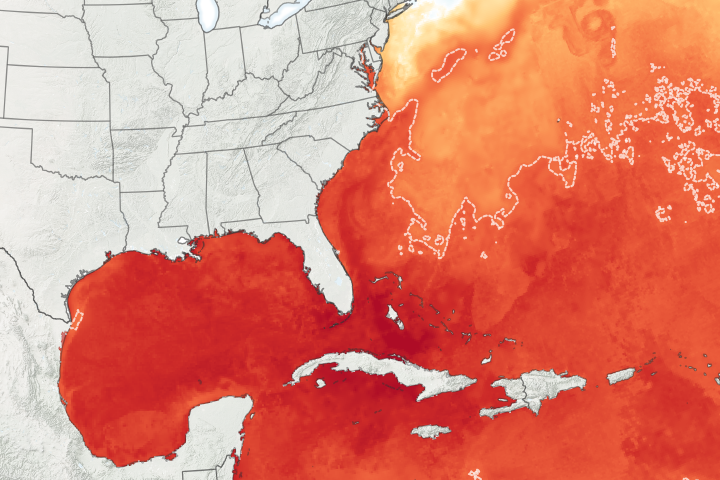
The first month of the 2009 Atlantic hurricane season drew to a close without so much as a tropical storm, but that isn’t unusual. According to the National Hurricane Center, the 1944-2002 average for named storms in June was only about 0.75, which means they don't occur every year. When they do form, it is usually the Gulf of Mexico that brews them up, and this image of sea surface temperatures on June 30, 2009, shows why.
Based on a blend of observations from the Moderate Resolution Imaging Spectroradiometer (MODIS) and the Advanced Microwave Scanning Radiometer for EOS (AMSR-E) on NASA’s Aqua satellite and MODIS on the Terra satellite, the image shows temperatures that are generally warm enough to sustain hurricanes in yellow, orange and red. The waters of the Caribbean Sea (south of Cuba), the Gulf of Mexico, and the Atlantic off the Southeast coast were all warm enough to fuel hurricanes, while most of the tropical Atlantic between the Americas and Africa was still too cool.
The northwestern Caribbean Sea, the Gulf of Mexico, and the nearshore waters of Florida, Georgia, and the Carolinas are all considered “likely” areas for June tropical storm formation (white dashed outline), but storms are especially likely in the northeastern Gulf of Mexico (white oval). The black lines on the image show the average paths that June storms tend to follow. One track takes storms through the Caribbean Sea, brushing the western tip of Cuba, and arcing across northern Florida to follow the warm waters of the Gulf Stream. The other track favored by June storms is in the western Gulf of Mexico. Storms cross Mexico’s Yucatan Peninsula and head north toward the Texas side of the U.S. Gulf Coast.
Storms occur often enough in June and July for those months to be considered part of the hurricane season, but named storms don’t really start to accumulate until August. By the end of July there still will have been fewer than two named storms on average; by the end of August, the number is closer to five.
NASA image by Jesse Allen and Robert Simmon. Caption by Rebecca Lindsey.