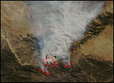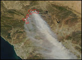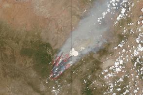
The Day Fire was burning dangerously close to Interstate 5 in Southern California on September 12, 2006, when the Moderate Resolution Imaging Spectroradiometer (MODIS) on NASA’s Terra satellite captured this image. The fire started on September 4, apparently from a campfire gone out of control in Los Padres National Forest, said the Forest Service. Dry conditions on the ground and hot, dry weather combined to allow the fire to grow to 27,131 acres by September 13. The fire was 25 percent contained at that time.
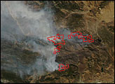
The fire’s eastern front was moving towards Interstate 5, one of California’s busiest roads, on the afternoon of September 12. The Interstate corridor forms a pale, tan line near the outer-right edge of the fire in the top, photo-like image. The fire itself is outlined in red. It was producing thick plumes of smoke, which were blowing west away from the Interstate when the image was taken. Throughout the day, the Interstate closed when the flames approached or when shifting winds carried thick smoke over the road, decreasing visibility to unsafe levels, reported the Associated Press.
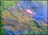
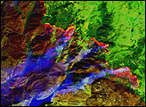
The lower image was made with infrared light instead of the visible light used to create the top image. Hot spots, perhaps areas of open flame, glow red-pink within the red fire boundaries. Smoke has a pale blue tint, and plant-covered land is bright green. Scorched land, where the fire had already burned, is brick red. Such images help fire and land managers assess the extent of the burn scar, the damage caused by wildfires.
Daily images of California are available from the MODIS Rapid Response System in both true color and infrared.
NASA image courtesy the MODIS Rapid Response Team, Goddard Space Flight Center