The Earth Observatory has published its last Image of the Day on this website. Please join us on our new home at science.nasa.gov/earth/earth-observatory.
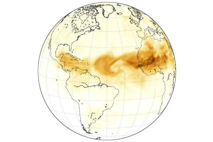
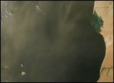
Each year, winds carry about 200 million tons of dust from North Africa over the Atlantic Ocean. NASA satellites often capture striking images of long streams of these tiny particles blowing over Senegal and Mali, enveloping Cabo Verde, and sometimes reaching as far as South America.
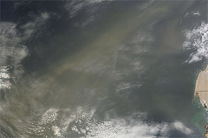
The image below, captured by the EPIC (Earth Polychromatic Imaging Camera) on DSCOVR (Deep Space Climate Observatory), shows a plume stretching across the Atlantic in June 2020, during one of the largest dust transport events of the past two decades. Nicknamed the “Godzilla” plume, the event affected air quality as far away as the Caribbean and the southeastern United States.
However, natural-color images like this, while dramatic, do not reveal the dust’s height in the atmosphere. “Accurately measuring dust height is crucial for tracking plumes in three dimensions, predicting dust’s impact on weather and climate, and assessing air quality risks,” said Jun Wang, the director of the Atmospheric and Environmental Research Lab at the University of Iowa.
Multiple satellites have measured dust height. For many years, the CALIPSO (Cloud-Aerosol Lidar and Infrared Pathfinder Satellite Observation) satellite used lidar to measure dust height by emitting laser pulses that travel through the atmosphere. Using this active sensor, scientists calculated the height of atmospheric particles by measuring the time it took for light to return to the detector after reflecting off particles in clouds, dust plumes, volcanic ash trails, and haze.
A lidar system on the International Space Station, known as CATS (Cloud-Aerosol Transport System), made similar measurements between 2015 and 2017. The ATLAS (Advanced Topographic Laser Altimeter System) lidar on ICESat-2 (Ice, Cloud, and Land Elevation Satellite-2) continues to use this technology.
A challenge with lidar, however, is that these instruments can only monitor a small fraction of the atmosphere. For example, CALIPSO sampled less than 0.2 percent of the atmosphere every two days during its 17-year mission, which ended in 2023.
To fill the gap, researchers are turning to passive remote sensing technology such as EPIC, which detects naturally emitted energy from the environment. From its position 1 million miles from Earth, EPIC observes the entire Atlantic Ocean every one to two hours. Some of the sunlight reflected from Earth and detected by EPIC is used to create natural-color images like the one at the top of this page. However, the sensor also detects light at several other wavelengths, or “bands,” which can be used to observe clouds, ozone, vegetation, or other features on Earth.
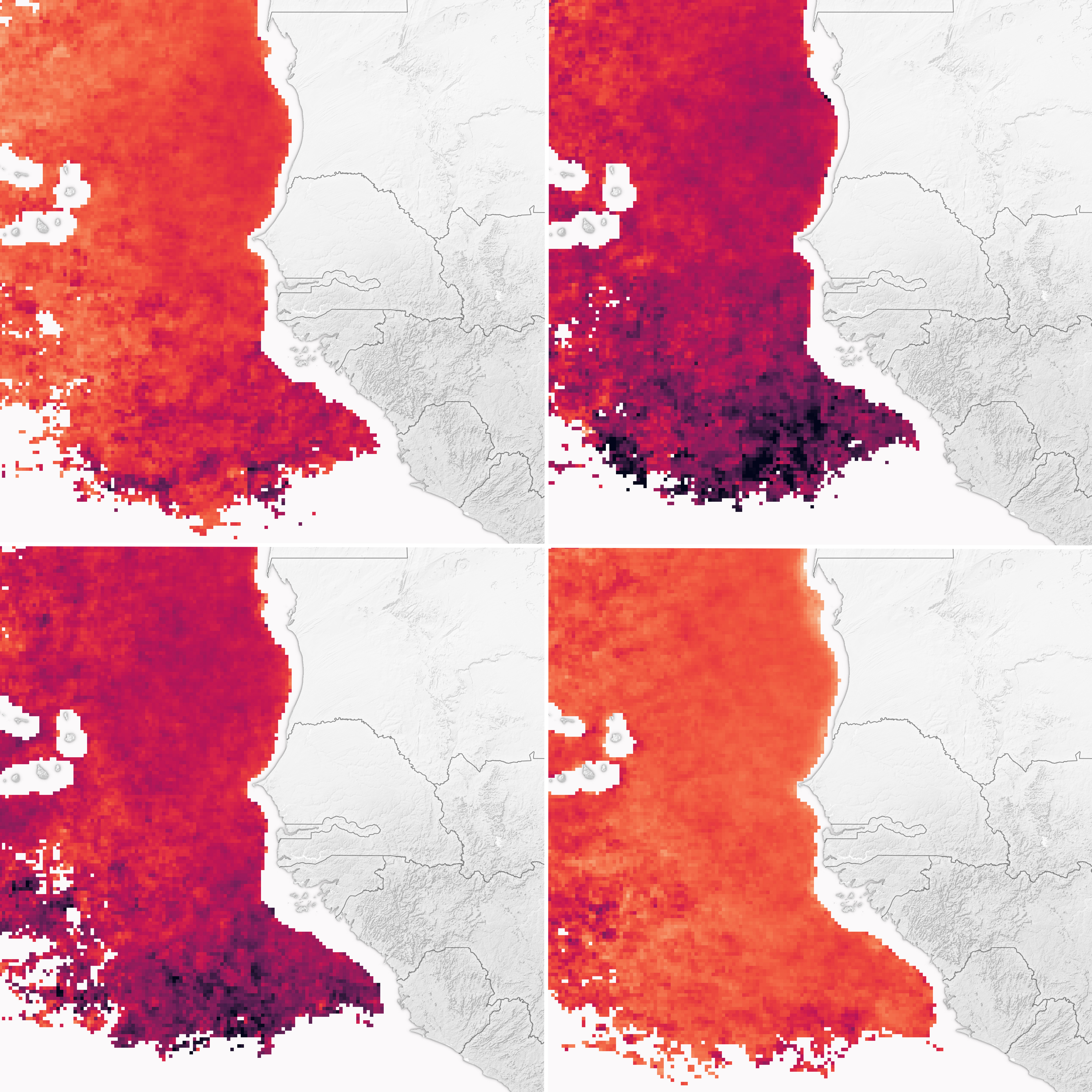
“EPIC wasn’t designed to measure dust height,” explained Wang. “However, our team at the University of Iowa has developed an algorithm that derives that information using information from its oxygen A and B bands.”
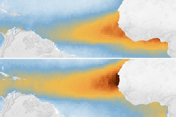
Using this algorithm and four years of EPIC observations, the University of Iowa team mapped daily variations in dust height over the Atlantic. The map above shows average dust height at various times of the day during the May-to-October wet season for the years 2015-2019. During this period, daytime convection and winds pull dust to heights of about 5-7 kilometers (3-4 miles) in the late morning and early afternoon as sunlight heats the water and clouds bubble up, explained Edward Nowottnick, an atmospheric scientist at NASA’s Goddard Space Flight Center.
Other NASA sensors, such as MISR (Multi-angle Imaging Spectroradiometer), also measure dust height, but only once per day. “The improvement with EPIC is that we can track dust height throughout the day at one- to two-hour intervals,” said Nowottnick.
Understanding the height cycles of airborne dust could advance research on multiple fronts, according to the scientists. Meteorologists will study dust's effects on hurricanes. Biologists will study how dust fertilizes ocean phytoplankton blooms. Air pollution experts are interested in its role in air quality degradation and health risks.
“Global models, such as NASA’s Goddard Earth Observing System (GEOS), do not represent daily dust height variations well,” Wang added. “With this EPIC data, models can be updated and improved.”
NASA Earth Observatory image by Wanmei Liang and Joshua Stevens using data from Lu, Z. et al. (2023) and imagery from the Deep Space Climate Observatory (DSCOVR). Story by Adam Voiland.