The Earth Observatory has published its last Image of the Day on this website. Please join us on our new home at science.nasa.gov/earth/earth-observatory.
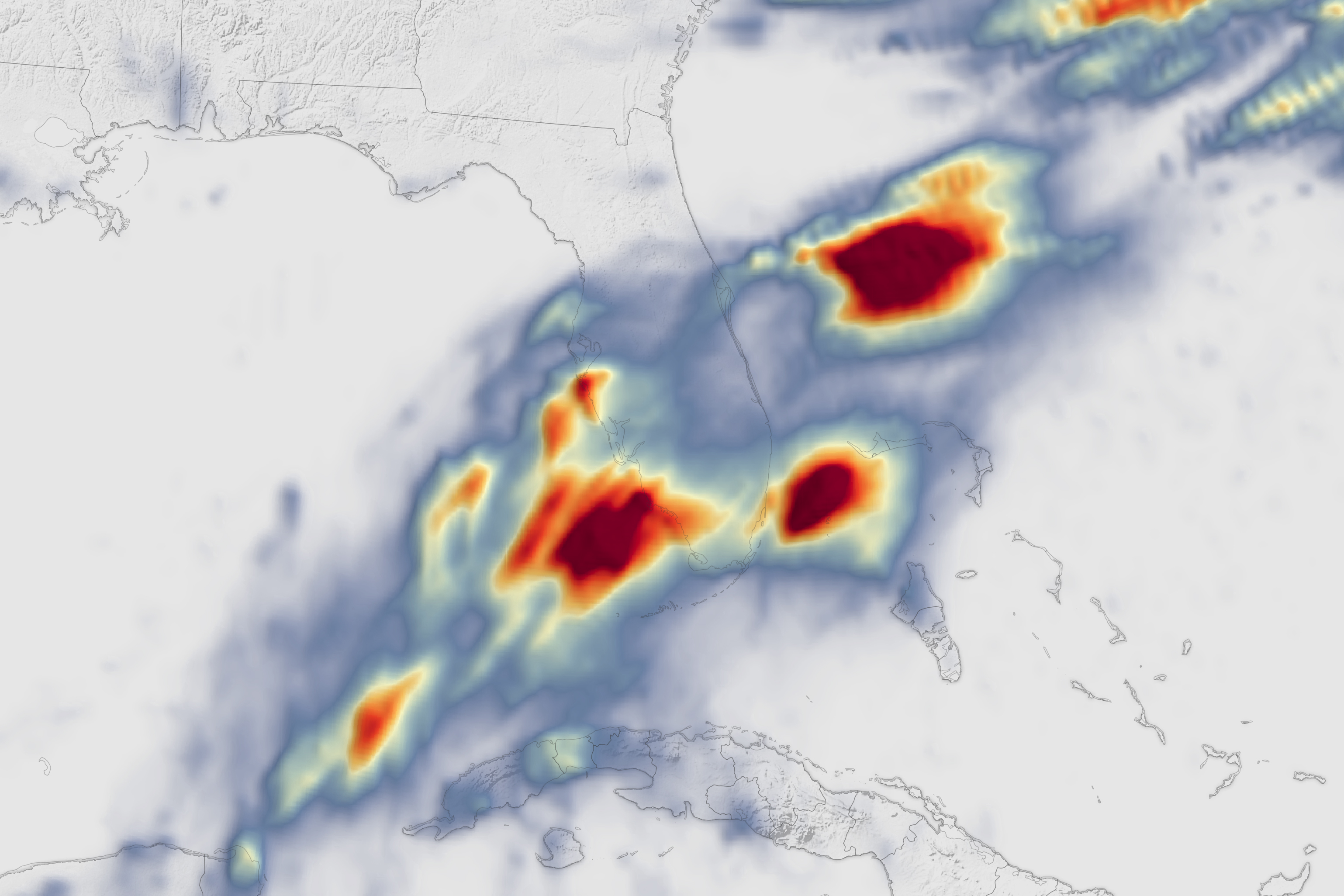
A plume of moisture from the western Caribbean delivered heavy rainfall to parts of southern Florida, particularly along its Gulf Coast, in June 2024. Intense precipitation from a slow-moving storm system triggered flash flood warnings and inundated roadways, while several cities set new daily precipitation records for June 11. Statistically, an event this severe should only occur once every 500 to 1,000 years, said meteorologists.
The map above shows rainfall accumulation for the 24-hour period starting at 00:00 Universal Time on June 11 (8 p.m. local time on June 10). These data are remotely-sensed estimates that come from IMERG (the Integrated Multi-Satellite Retrievals for GPM), a product of the GPM (Global Precipitation Measurement) mission, and may differ from ground-based measurements. For instance, IMERG data are averaged across each pixel, meaning that rain-gauge measurements within a given pixel can be significantly higher or lower than the average.
Some of the highest rainfall totals were recorded in coastal Sarasota County. A National Weather Service (NWS) station in Sarasota measured 6.5 inches (16.5 centimeters) of rain for the 24 hours of June 11 (local time), breaking that date’s record of 2.5 inches, set in 1940. Nearby locations saw up to 10 inches that day, according to NWS Tampa Bay. The rain was intense at times; a record 3.9 inches fell in one hour around 7 p.m. local time at the Sarasota-Bradenton Airport, toppling the previous hourly rainfall record by nearly an inch. Normal precipitation for the entire month of June is 7 inches.
Farther south along the coast, Fort Myers and Naples set new records for precipitation on June 11. Miami verged on record-rainfall territory, according to NWS measurements, and the inclement weather caused hundreds of flight delays and dozens of cancellations at the Miami and Fort Lauderdale airports, according to news reports.
Forecasters called for bouts of heavy rainfall and a risk of localized flash flooding across Florida over the next several days as tropical moisture continues to stream in and converge with a stationary front to the north. The rain brought some relief to drought conditions that had developed across central and south Florida.
NASA Earth Observatory image by Lauren Dauphin, using IMERG data from the Global Precipitation Mission (GPM) at NASA/GSFC. Story by Lindsey Doermann.