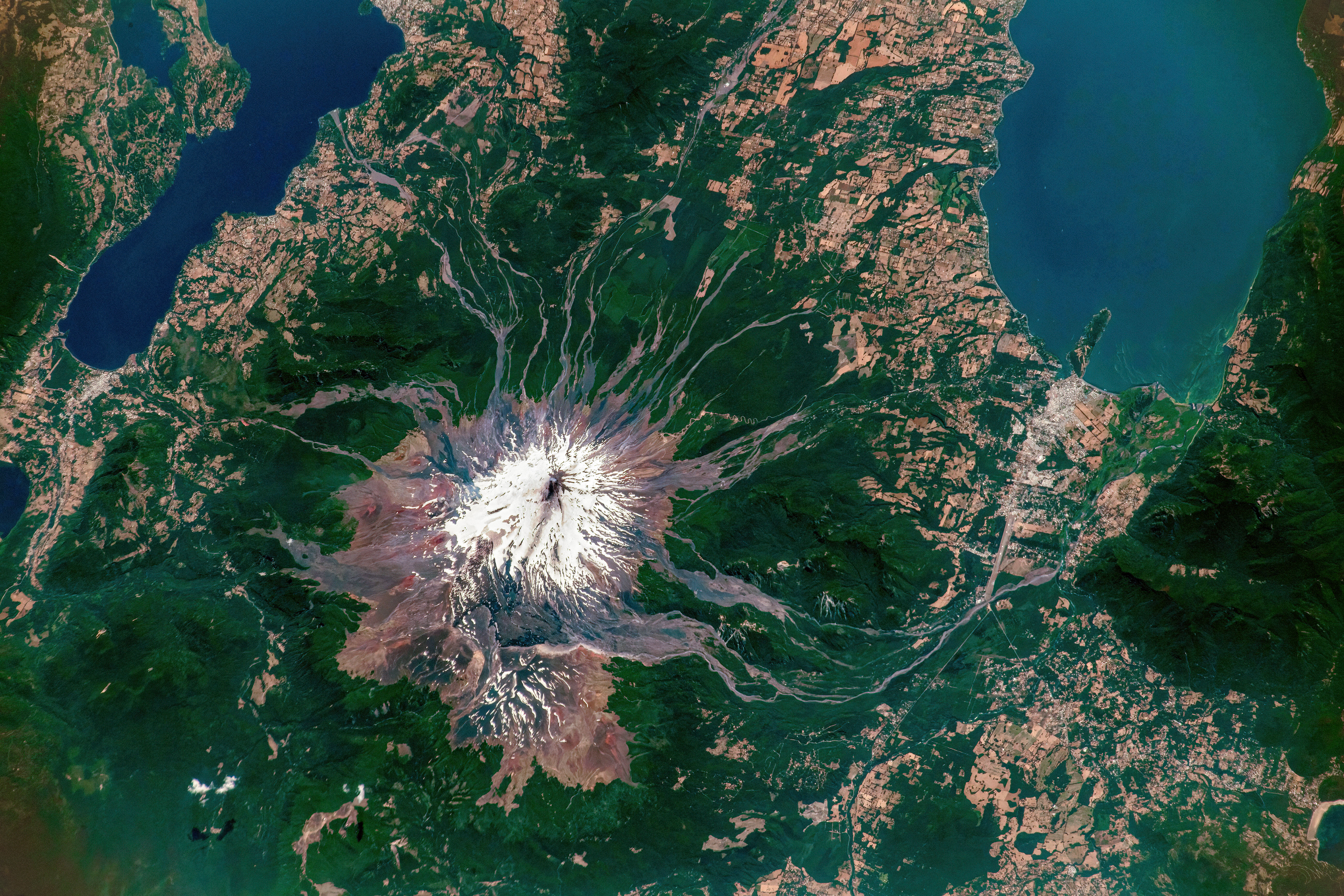
Plumes of steam and other volcanic gases from Chile’s Villarrica volcano were captured in this photo taken from the International Space Station on January 17, 2023. They are a product of a series of minor explosions that have been ongoing at Villarrica since October 2022.
Located along Chile’s southern Andes, Villarrica is one of the most active volcanoes in South America. In the inset, steam is coming from Villarrica’s crater. A streak of ash is visible on the volcano’s snow-covered eastern flank. In this view, north is toward the right side of the image.
Chile’s National Geology and Mining Service (Sernageomin) reported daily, minor Strombolian explosions in January 2023, which have ejected glowing rock as high as 100 meters (330 feet) above the crater rim. An increase in earthquakes and sulfur dioxide emissions in late October and early November 2022 led to Sernageomin raising the alert level from green to yellow on November 8, 2022.
Low-level Strombolian activity is common at Villarrica. Strombolian volcanic activity is named after the Stromboli volcano in Italy, which is known for its firework-like eruptions.
“Strombolian eruptions are short, lasting minutes,” said Francisco Delgado, a volcanologist at the University of Chile. “These small basaltic eruptions happen when a big bubble of water vapor fragments the lava. The fragments explode into the air and solidify as pyroclasts.”
Villarrica is one of the most dangerous volcanoes in the southern Andes volcanic zone of Chile and Argentina (between 33°S and 46°S latitude), and typically erupts every three to six years. Its last major eruption was on March 3, 2015, when thousands of people evacuated within a 10 kilometer (6 mile) radius of the mountain.“That was the largest eruption since 1985,” said Delgado, who studies volcanoes in the southern Andes using both on-the-ground instruments and remote sensing.
Typically, one of the first signs a volcano is becoming restless is ground uplift or deformation. Delgado uses synthetic aperture radar (SAR) data to measure ground deformation caused by the movement of magma beneath the volcano. By looking at the difference between surface topography from two different time periods, scientists can tell how much the ground is changing, a method called interferometric synthetic aperture radar (InSAR).
Information on ground deformation is used by volcano observatories—along with other data sources—to set alerts for volcanoes. Although in many cases ground deformation precedes volcanic activity—such as before the 2018 Kilauea eruption—Villarrica didn’t show these signs before the March 2015 eruption.
“Villarrica is more complicated,” said Delgado. Villarrica is an open vent volcano, with an exposed lava lake at the top, and rising magma isn’t typically associated with deformation. To detect rising magma preceding an eruption at Villarrica, seismology or thermal anomaly data from NASA’s Moderate Resolution Imaging Spectroradiometer (MODIS) may be more effective.
As of January 27, the alert level for the volcano was still elevated at yellow (the second level on the four-color scale).
Astronaut photograph ISS068-E-40596 was acquired on January 17, 2023, with a Nikon D5 digital camera using a focal length of 420 millimeters. It is provided by the ISS Crew Earth Observations Facility and the Earth Science and Remote Sensing Unit, Johnson Space Center. The image was taken by a member of the Expedition 68 crew. The image has been cropped and enhanced to improve contrast, and lens artifacts have been removed. The International Space Station Program supports the laboratory as part of the ISS National Lab to help astronauts take pictures of Earth that will be of the greatest value to scientists and the public, and to make those images freely available on the Internet. Additional images taken by astronauts and cosmonauts can be viewed at the NASA/JSC Gateway to Astronaut Photography of Earth. Story by Emily Cassidy.