The Earth Observatory has published its last Image of the Day on this website. Please join us on our new home at science.nasa.gov/earth/earth-observatory.
A fierce multiday storm in mid-December 2022 had far-reaching effects across the United States, first slamming California and then hitting the Plains and Upper Midwest with snow and ice. The storm was especially volatile in the U.S. South, where severe thunderstorms and destructive tornados swept across multiple states.
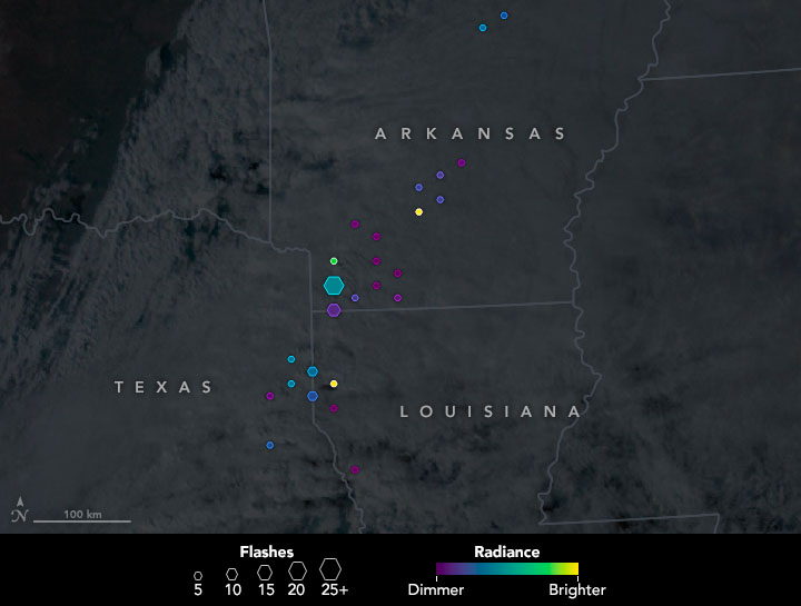
The map above represents lightning flashes detected over Texas, Louisiana, and Arkansas between 3:31 p.m. and 3:33 p.m. Central Time (21:31 and 21:33 Universal Time) on December 13, 2022. Data for the map are from the Lightning Imaging Sensor on the International Space Station (ISS-LIS). The instrument detects all types of lightning—cloud-to-cloud, intra-cloud, and cloud-to-ground—and measures the number and rate of these flashes, as well as their radiant energy.
The size of the symbols on this map represents the number of lightning flashes. LIS detected more than 100 flashes in just a few minutes that afternoon, with more than 50 events represented by the largest hexagon. Colors indicate the flashes’ radiant energy, or brightness. The lightning data are overlaid on an image of the storm acquired at 3:30 p.m. Central Time on December 13 with NOAA’s Geostationary Operational Environmental Satellite (GOES).
According to Christopher Schultz, a meteorologist at NASA’s Marshall Space Flight Center who studies lightning flash rates and severe weather, there was a “jump” in flashes around the time the flash data for this map were acquired. Lightning jumps—a rapid increase in a thunderstorm’s total lightning count—indicate a strengthening storm and increasing potential for severe weather.
“The rate of change provides critical lead time that significant changes are occurring in the storm, providing time to warn those in the path,” Schultz said.
Indeed, the U.S. South saw numerous tornadoes on December 13, including an EF2 that touched down in eastern Texas between 3:38 p.m. and 3:52 p.m. Central Time. The storm struck a forested area of Panola County and ripped up hundreds of trees before moving into Harrison County. No fatalities or injuries were reported, though several homes were damaged.
Schultz and colleagues at NASA Marshall and NASA’s Jet Propulsion Laboratory are working to better understand the amount of lightning energy observed by instruments in orbit, and how it relates to the underlying storm structure.
“It is our goal to use the light energy we receive through LIS and NOAA’s Geostationary Lightning Mapper measurements to enhance the lightning jump algorithm we’ve developed in conjunction with partners at NOAA to improve severe storm identification,” Schultz said. “The events of the last few days provide examples of extreme convection that we can use as benchmarks in these analyses.”
NASA Earth Observatory image by Joshua Stevens, using data from the Lightning Imaging Sensor at the Global Hydrometeorology Resource Center (GHRC) and GOES-16 imagery courtesy of NOAA and the National Environmental Satellite, Data, and Information Service (NESDIS). Story by Kathryn Hansen.