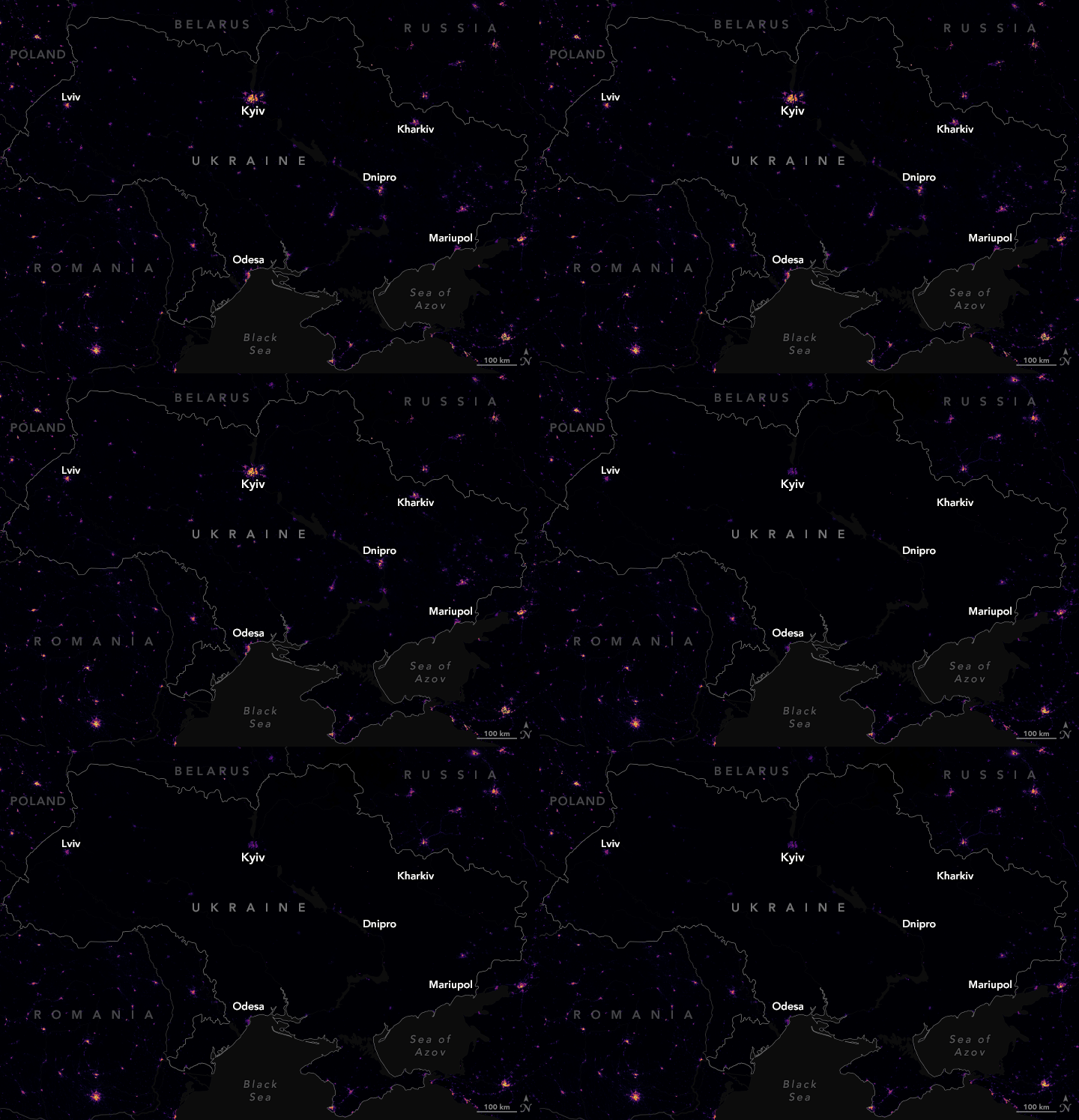

Using the nighttime sensing capabilities of instruments on NOAA–NASA satellites, scientists from NASA’s Goddard Space Flight Center (GSFC) and the Universities Space Research Association (USRA) have observed the changes in light usage around Ukraine since January 2022. After a significant reduction of lights in March, power has slowly been restored and regular human activity has appeared to pick up in several parts of the country, particularly around the capital.
The Visible Infrared Imaging Radiometer Suite (VIIRS) on the Suomi-NPP satellite measures nighttime light emissions and reflections via its day-night band. This sensing capability makes it possible to distinguish the intensity of lights on Earth’s surface and how they change.
“It is generally hard to get data about conflict areas, which makes satellite imagery quite powerful. These data show us one dimension of how the impacts of the conflict have been distributed within Ukraine,” said Eleanor Stokes, a USRA scientist and co-leader of the Black Marble Project. “In the short term, the data are useful for humanitarian relief agencies because they provide estimates of where and how many people have lost access to basic services, which exacerbates the loss of life.”
“In the longer term, scientists use this data to understand how conflict has impacted development outcomes and the economy,” Stokes added. “Black Marble is also special as a way of tracking recovery from conflict because lights generally follow people. We have worked with organizations like the Internal Displacement Monitoring Centre to help assess where displaced persons are most likely to have fled from and to track their return home.”
The maps at the top of this page show nighttime lights around Kyiv, Ukraine, for the entire months of March and May 2022. Ranjay Shrestha (NASA GSFC) and the Black Marble team selected the best cloud-free nights in each month, then processed and analyzed the VIIRS data to produce composites of nighttime lights. The lights data have been overlaid on a base map built from Landsat 9 near-infrared observations (band 5) that helps distinguish the built environment from the natural. The third image above is a composite view of light across the region in January 2022, before the war began. The animation below shows changes across the entire country from January to May 2022.

“In the first few months of the war, electricity and basic services were attacked in several major cities,” said Stokes. “As the war continued into May, we saw a shift—some continued loss of lights in eastern Ukraine and some recovery in the western part of Ukraine. The Black Marble HD images show recovery in the outskirts of Kyiv, in particular, as residents returned to the capital city.”
Power plants and other infrastructure were systematically damaged in the early weeks of the war, cutting off electricity to millions of people. Some outdoor lighting also may have been intentionally dimmed, removed, or shut off, noted Sergii Skakun, a University of Maryland researcher who grew up in Ukraine and has studied night lights in the region. According to media reports, crews have since been able to restore substations and high-voltage power lines in some regions of Ukraine. However, many areas remain without significant nighttime lighting—perhaps because of a lack of power or perhaps due to intentional choices to keep the lights off.
International agencies such as the United Nations Institute for Training and Research Operational Satellite Applications Programme (UNITAR-UNOSAT) use night lights imagery to track conflicts. Nighttime imagery also helps relief and peacekeeping groups identify areas that are most in need of aid and support.
Precision is critical for studies with night lights. Raw, unprocessed images can be misleading because moonlight, clouds, air pollution, snow cover, seasonal vegetation—even the position of the satellite—can change how light is reflected. The Black Marble research team calibrates its measurements to account for changes in the landscape, the atmosphere, and Moon phase, and to filter out stray light from sources that are not electric lights.
NASA Earth Observatory images by Joshua Stevens, using Black Marble data courtesy of Ranjay Shrestha/NASA Goddard Space Flight Center. Story by Michael Carlowicz.