The Earth Observatory has published its last Image of the Day on this website. Please join us on our new home at science.nasa.gov/earth/earth-observatory.
Satellite views of Earth at night have proven useful for disaster response and recovery, for detection of population changes and urban development, for studies of energy consumption, and many other uses. Since the 2011 launch of the NOAA-NASA Suomi NPP satellite—as night light data have become freely available to scientists and the public within hours of acquisition—the applications have proliferated.
Ocean conservation researchers have found another use for nighttime imagery: tracking unregulated, under-reported, and sometimes illegal fishing. When combined with commercial fishing reports and ship identification systems, night light data have revealed patterns of deep-sea fishing that may be unsustainable for ecosystems and detrimental to countries with less advanced fishing fleets. In the Indian Ocean alone, the UN Food and Agriculture Organization (FAO) estimates that 30 percent of assessed fish stocks are being fished beyond sustainable limits.
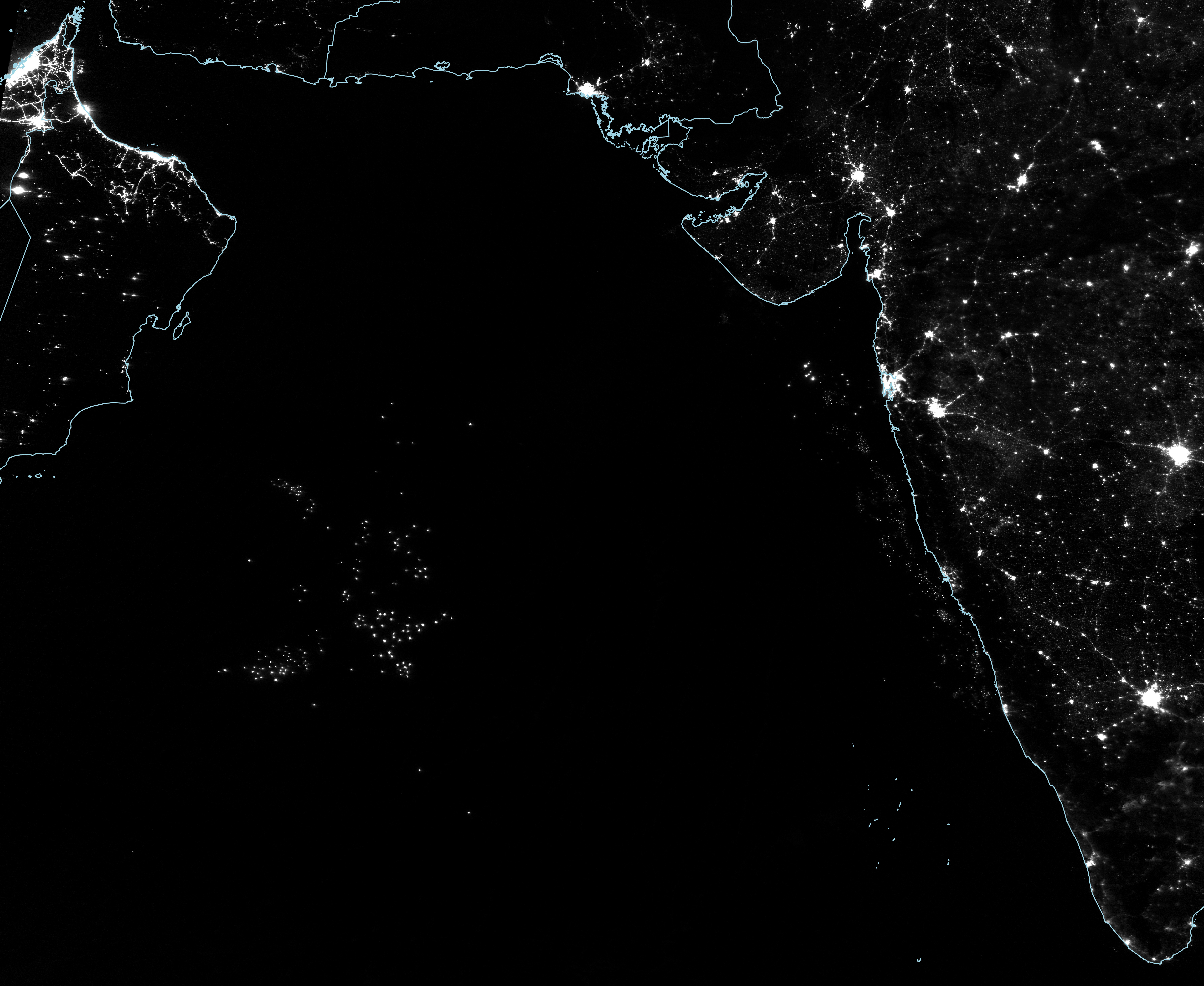
The nighttime image above was acquired on February 15, 2021, by the Visible Infrared Imaging Radiometer Suite (VIIRS) on Suomi-NPP. VIIRS has a specially designed day-night band that detects nighttime light in a range of wavelengths from green to near-infrared and uses filtering techniques to observe signals such as city lights, reflected moonlight, and fishing boats. A second VIIRS instrument flies on the NOAA-20 satellite.
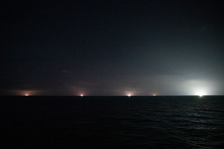
In the image above, points of light in the Arabian Sea (northwest Indian Ocean) indicate the locations of fishing boats, refrigerated cargo ships, and perhaps a few other large ships. The fishing boats stand out because they use high-intensity lights to draw squid, saury, and other fish toward the water surface, where they are more easily caught with jigging lines and purse seine nets. Squid boats can carry more than a hundred lamps and generate as much as light as a house. The photo below (courtesy of Trygg Mat Tracking) shows fishing boats lighting up the horizon of the Arabian Sea in April 2021.
“It’s a gold rush out there,” said Joaquim Goes, a marine ecologist at Lamont Doherty Earth Observatory. “The area is rich in squid, and it is just outside of the exclusive economic zones of Oman, Yemen, India, and Pakistan.”
Fishing in this part of the northwest Indian Ocean has expanded every year since 2015, according to a 2020 report by Trygg Mat Tracking, the World Wildlife Fund, and Global Fishing Watch (GFW). At first, boats were mostly observed from November through January; the fleets now show up regularly from September to May. Most vessels stay out of the region during monsoon season. Overall, the number of fishing vessels regularly working this area increased from about 30 in 2015 to nearly 300 by 2019. (GFW has created an animation of the Arabian Sea fleet pattern.)
While the fishing here is not illegal, it is unregulated, and ocean conservation groups and the FAO are concerned about sustainability and equity. The squid catch is used for both direct human consumption and for fish meal for the aquaculture industry. Squid and saury are also prey for tuna, swordfish, and other species in the Indian Ocean, and it is unclear how those fisheries are affected by squid harvesting. The equity questions arise from the use of high-tech equipment by some foreign vessels when such gear is not affordable or allowed by developing nations in Africa and southwest Asia that rely on these fisheries for food security and economic health.
As global demand for seafood continues to rise, it becomes ever more important to have a clear view of ocean activities and their potential consequences, noted Duncan Copeland, executive director of Trygg Mat Tracking, a nonprofit institute that monitors fishing. “We face destabilizing both marine ecosystems and the marine resources that many people depend on for income and food security,” he said.
Vessel tracking starts with Automatic Identification System (AIS) transponders, which are designed to prevent collisions at sea by constantly transmitting a ship's location, and vessel monitoring systems (VMS), which are designed for fisheries monitoring and surveillance. The International Maritime Organization has mandated that all ships larger than 300 gross tons must use the AIS system while traveling internationally. The signals are collected by satellite and broadcast to mariners and shipping agencies.
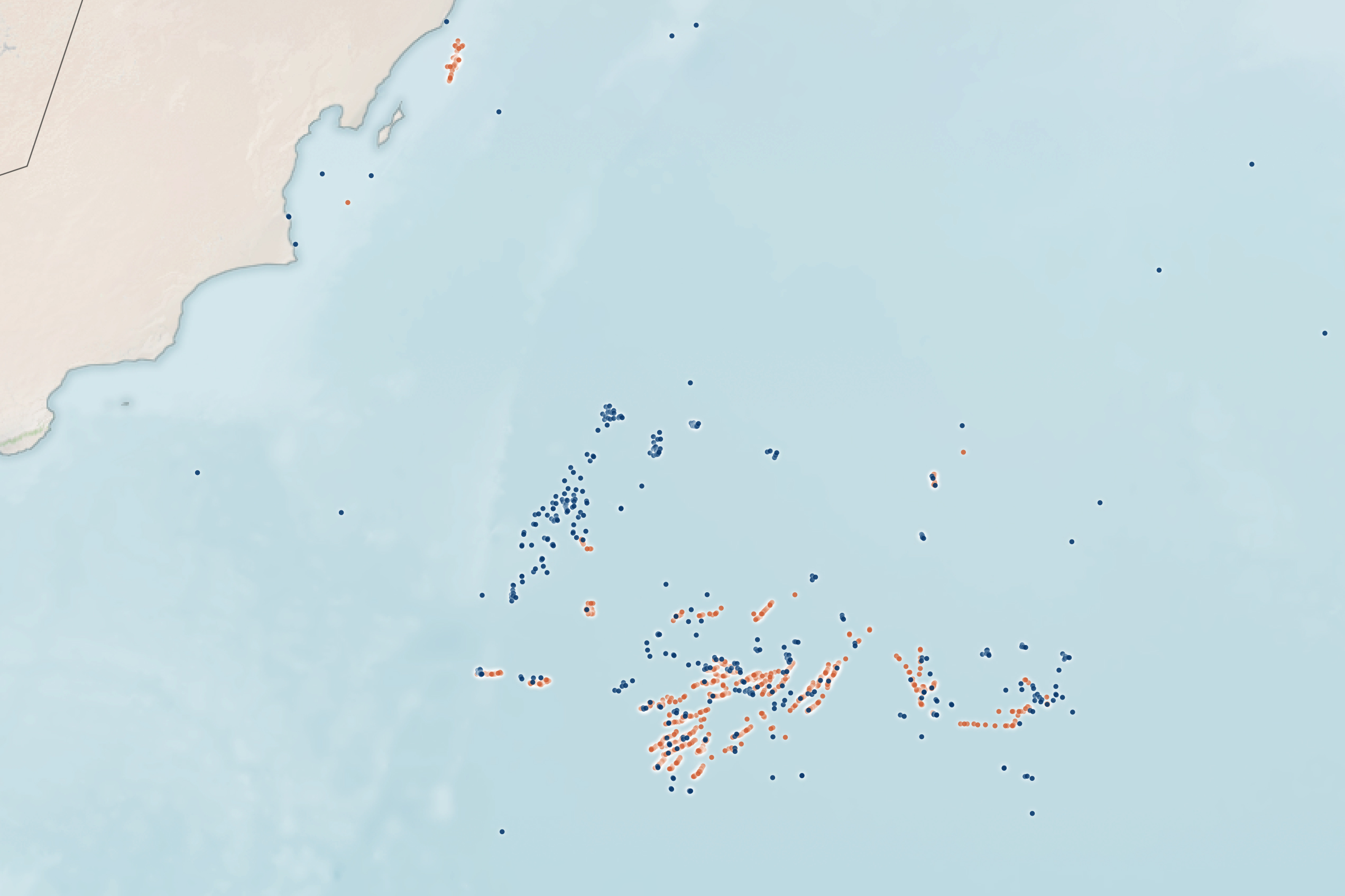
Since AIS data are publicly available, GFW and other groups used it to track global ship movements from port to sea and back. They employed machine learning to analyze more than 30 billion AIS messages and identify shipping patterns. For instance, the data mining revealed the use of refrigerated cargo vessels, which transfer the fishing catch from smaller boats and transport it back to port while the fishermen continue to work offshore for weeks to months. According to GFW, “Only a small proportion of the world's approximately 2.9 million fishing vessels are equipped with the AIS system, but they are responsible for a disproportionate share of the fish caught.”
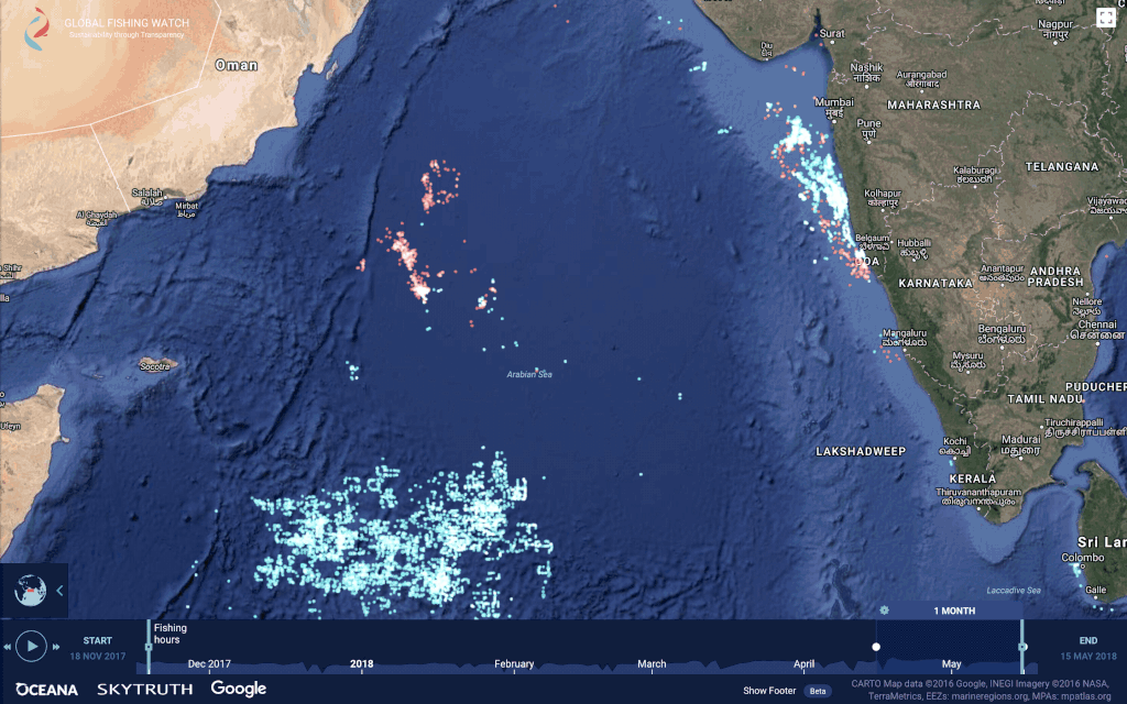
AIS signals alone cannot capture the full scale of industrial fishing. Signal interference and faulty equipment can distort ship numbers; other times, fishing boats turn off the beacons in order to avoid pirates or fishing enforcement agencies. This is where night light detection can reveal what official systems might not detect. The map above, derived from Global Fishing Watch data, shows ships detected by AIS beacons in orange and those detected by VIIRS day-night band in blue.
“Worldwide, the VIIRS instruments are detecting 10,000 to 20,000 boats every night that are not broadcasting AIS or VMS. By detecting the signal from lights present on fishing vessels we can calculate a better estimate of the size of certain fleets,” said Chris Elvidge, who developed VIIRS boat-detection tools while working for NOAA. Elvidge and colleagues at GFW found that more than 85 percent of their VIIRS detections came from vessels that lacked AIS or VMS.
“VIIRS supports our AIS and VMS data, and it complements other imagery sources like synthetic aperture radar and optical imagery,” said Nate Miller, senior data scientist at GFW. “Each of these technologies has strengths and limitations, but by combining them we are able to create a more complete picture of fishing.”
NASA Earth Observatory images by Lauren Dauphin, using VIIRS day-night band data from the Suomi National Polar-orbiting Partnership and AIS-based fishing effort and vessel presence data from Global Fishing Watch. Photograph copyright Trygg Mat Tracking. Story by Michael Carlowicz.


