Bangladesh has a long history of deadly and costly storms. Among the most worrisome are kalbaishakhi, small but powerful storm cells that tend to affect the country in the spring. Kalbaishakhi were responsible for a 1989 tornado that is believed to be the deadliest in world history, as well as a lightning strike at a wedding party in 2021 that caused 17 deaths. Because these storms are so localized, they can be notoriously difficult to forecast, especially without access to the most advanced weather prediction technology.
“Bangladesh is a hotspot for high-impact weather events—intense rainfall, damaging wind and hail, frequent lightning strikes, and cyclones,” said Azizur Rahman, director of the Bangladesh Meteorological Department (BMD). “And the science is clear: Because of climate change, these high-impact weather events will be more frequent and more intense in the future.”
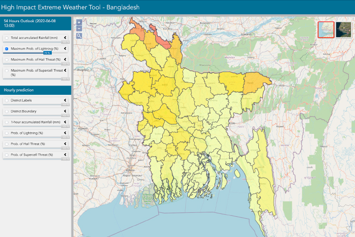
Researchers have created a new tool to boost the country’s ability to forecast kalbaishakhi and other severe weather. The U.S.-based SERVIR program and the BMD recently launched the High-Impact Weather Assessment Toolkit (HIWAT), a web-based tool (shown below) that integrates data from NASA’s Earth-observing satellites with BMD’s local observations in order to improve weather forecasts. The project was led by Patrick Gatlin, a research meteorologist at NASA’s Marshall Space Flight Center, with SERVIR’s Hindu-Kush Himalaya team at the International Centre for Integrated Mountain Development (ICIMOD).
The reliability of weather forecasts is largely dependent on the quality of geographic coverage from weather stations. If a country has only a few weather stations, and if those stations do not have long records, meteorologists do not have as much context to guide future predictions.
Bangladesh has a short history of weather data gathering, and until recently the country lacked public funding for satellites and the powerful computers needed to run advanced prediction models. Without such resources, BMD forecasters were looking for additional data.
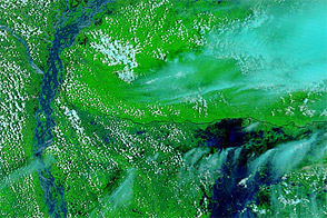
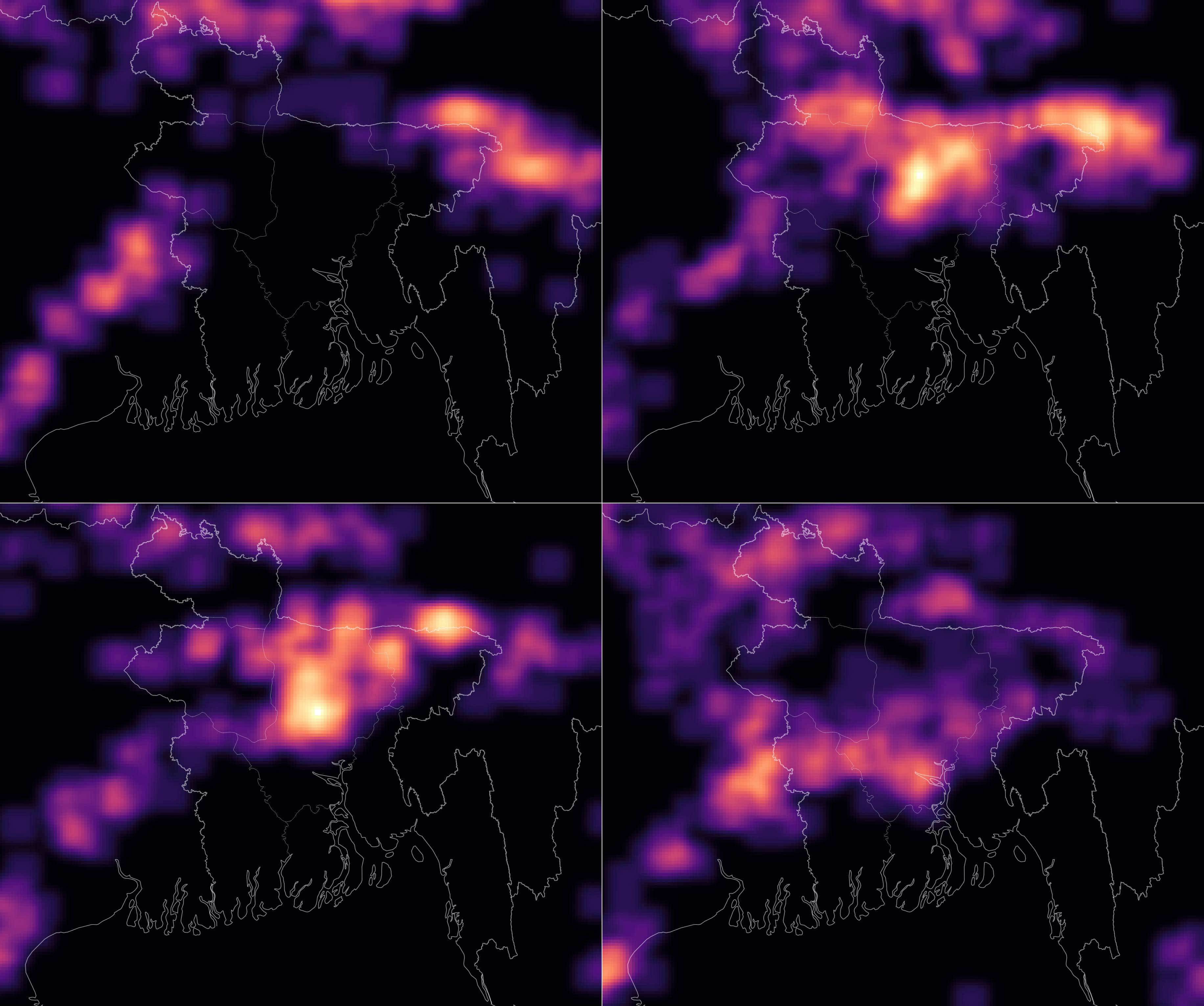
“Due to limitations in the processes as well as the facilities of BMD, we have not been able to provide lightning forecasts in a proper way,” said Abdul Mannan, a meteorologist with the BMD’s Storm Warning Centre. The map above, derived from HIWAT data, shows a lightning forecast for May 16-19, 2022, during a storm event in Bangladesh.
HIWAT feeds data from NASA’s Global Precipitation Measurement mission and other sources into the forecasting process, giving BMD meteorologists a more thorough and detailed pool of data. Those inputs can help produce more reliable forecasts and allow scientists to predict hazards that were previously more difficult to anticipate, like lightning and hail. Around the time of the launch of HIWAT, the Bangladeshi government also announced it would provide BMD with powerful computer servers to further advance the speed and reliability of forecasts.
SERVIR is a joint program of NASA and the U.S. Agency for International Development. Researchers collaborate with geospatial organizations in Asia, Africa, and Latin America to support decision-making for climate adaptation and natural resource management. SERVIR also helps partners design satellite-based tools for addressing issues like air quality and disaster management.
Because forecasts are imperative to decision-making across many sectors—particularly agriculture or disaster management—weather and climate services are critical to SERVIR’s mission. SERVIR and BMD intend for HIWAT to enable not only better forecasts, but better public safety warnings as communities prepare for a changing climate.
NASA Earth Observatory image by Lauren Dauphin, using data from the High Impact Weather Assessment Toolkit (HIWAT) team at NASA’s Marshall Space Flight Center (MSFC) and the NASA SERVIR Applied Sciences Team. Story by Jake Ramthun, SERVIR, with Mike Carlowicz.
Researchers with SERVIR created a web-based tool that integrates NASA satellite data with observations from the Bangladesh Meteorological Department.
Image of the Day for June 21, 2022
View more Images of the Day:

alert message