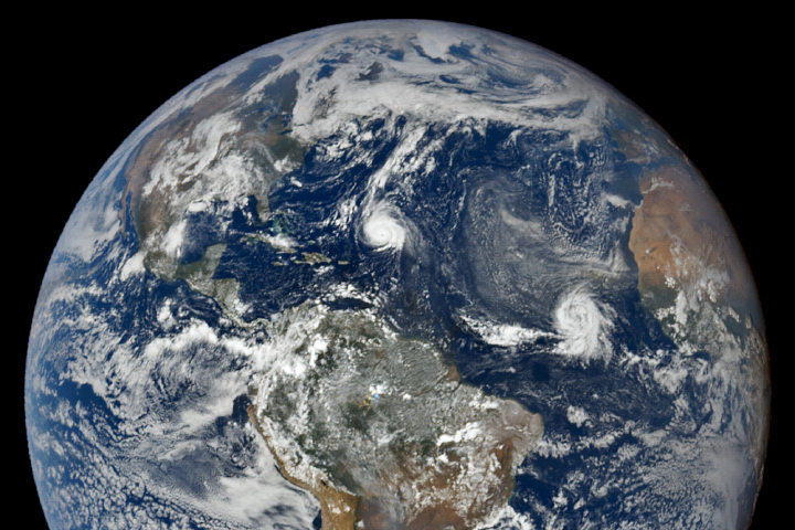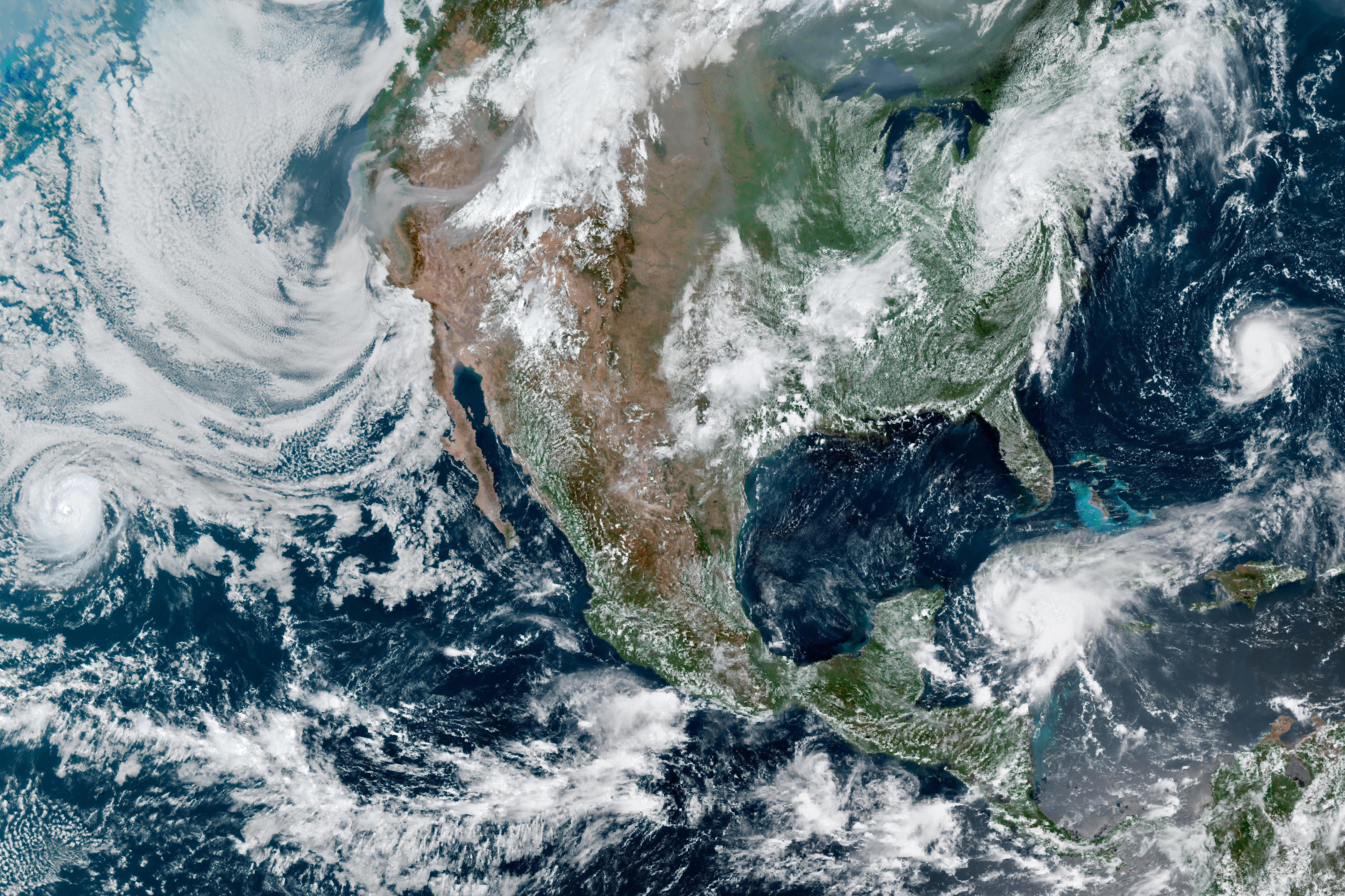
The pace of hurricane activity around North America often accelerates in mid-to-late summer as seas warm, making it easier for tropical cyclones to develop and intensify. August 2021 was no exception. In fact, more storm activity has happened earlier in the year than usual.
When the Geostationary Operational Environmental Satellite 16 (GOES-16) acquired this image on August 18, 2021, four different storms at various stages of development churned around the continent. Meanwhile, smoke from several major fires raging in California was visible streaming across the western U.S.
After drenching Hispaniola, Hurricane Grace was strengthening and on a collision course with the Yucatan Peninsula. With a large ridge of high pressure in the U.S. Southeast blocking it from moving north, the storm was pushing west-northwest at 15 miles (24 kilometers) per hour. Before its approach to Mexico, Grace unleashed intense downpours in parts of Haiti that were struck on August 14 by a magnitude 7.2 earthquake, complicating recovery efforts and increasing the risk of landslides.
Meanwhile, the remnants of Tropical Storm Fred were moving northeast through the U.S. Mid-Atlantic after making landfall in the Florida Panhandle near Apalachicola. At landfall, the storm lashed that area with sustained winds of 65 miles (105 kilometers) per hour and delivered several inches of rain to parts of Florida, Alabama, and Georgia as it moved inland.
Fred was the fourth named storm to make landfall in the U.S. this year, following Claudette, Danny, and Elsa. There is a possibility that Henri, now offshore near the Bahamas, could become the fifth. Though the storm was far from the U.S. mainland when GOES acquired this image, National Hurricane Center forecasters say there is a possibility that the strengthening storm could veer west and cause direct impacts in the northeastern U.S.
“Starting early last week, the large-scale conditions became especially favorable for tropical cyclone development in the Eastern Pacific and Atlantic basins,” said Patrick Duran, a hurricane expert based at NASA’s Marshall Space Flight Center. “The Madden-Julian Oscillation, a global-scale phenomenon that plays a role in tropical convection, became favorable for thunderstorm formation. At the same time, a large atmospheric wave called an equatorial Kelvin wave moved across the Atlantic, making conditions even more favorable for storm development.”
In the Eastern Pacific, Linda achieved hurricane status on August 12 and remained a strong storm for several days. Though nowhere near land, the storm’s winds have reached as high as 130 miles (209 kilometers) per hour at times, enough for it to qualify as a category 4 hurricane.
Of note to meteorologists tracking Linda is that it appears to be an annular hurricane—a type of intense hurricane. They typically have especially large and symmetrical eyes and few rain bands spiraling outward. Annular hurricanes tend to be significantly stronger and maintain their peak intensities longer than other tropical cyclones. “The annular structure makes these storms more resistant to the negative impacts of unfavorable conditions, like low ocean temperatures or high wind shear,” explained Charles Helms, a scientist based at NASA’s Goddard Space Flight Center.
This simulated natural-color image was acquired at 1:20 p.m. Eastern Standard Time (17:20 Universal Time). It was captured by GOES 16’s Advanced Baseline Imager (ABI). The satellite is operated by the National Oceanic and Atmospheric Administration (NOAA); NASA helps develop and launch.
NASA Earth Observatory image by Lauren Dauphin, using GOES 16 imagery courtesy of NOAA and the National Environmental Satellite, Data, and Information Service (NESDIS). Story by Adam Voiland.