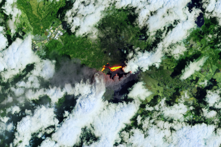
The Kafue River—the longest river flowing entirely within Zambia—winds more than 1500 kilometers (900 miles) until it joins the Zambezi River. Before reaching the Zambezi, the Kafue’s west-to-east course crosses a flat, shallow floodplain known as the Kafue Flats.
The disturbance caused by annual floods plays an important role in the Kafue Flats ecosystem. Historically, naturally occurring floods that peaked along the flats from March to May provided vital habitat for spawning fish; when the floodplain dried around October, grazers moved in to eat the newly grown grasses.
Dams built for hydropower in the 1970s upstream and downstream of Kafue Flats altered that rhythm. “Since the dams were built, the natural dynamics of high and low flows have been strongly reduced,” said Fritz Kleinschroth, a landscape ecologist at Swiss Federal Institute of Technology (ETH Zürich), who has used satellite images and field surveys to study decades-long changes in the region. “Nowadays, the less-flooded areas are dominated by shrublands, and the more permanently humid zones are comprised of reeds and species like papyrus.” With less water flowing through, trees and shrubs moved in, spawning grounds were lost, and human settlements were disturbed.
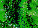
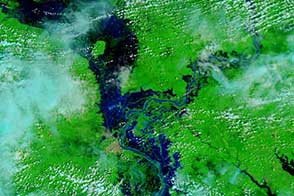
To reduce the impacts of this new streamflow, people began to mimic the natural flooding dynamics with artificial flood releases, or so-called “environmental flows.” The recently flooded Kafue Flats are visible in this image, acquired on April 1, 2021, with the Moderate Resolution Imaging Spectroradiometer (MODIS) on NASA’s Terra satellite.
The inundated network of channels and lagoons span the plain, which measures about 240 kilometers long and up to 50 kilometers wide (30 miles). It crosses moderately settled land: the town of Kafue lies along the north bank, and green areas southeast of the flats are irrigated sugar cane fields. River water also passes through Blue Lagoon and Lochinvar National Parks, but even these conservation areas have been altered.
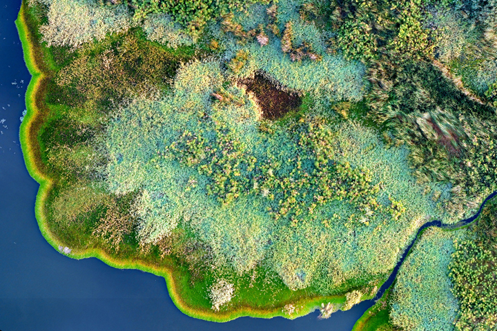
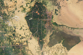
The photograph above shows a detailed view of the Kafue Flats wetlands, acquired via drone by ATEC-3D for a 2020 study by Kleinschroth and colleagues. The bright green fringe consists of water hyacinth and Amazon frogbit—two exotic floating plant species that the scientists observed amid other native and non-native aquatic plants.
“Biological invasions are a big issue both from ecological and economic points of views, and everything should be done to prevent the spreading of non-native species in the first place,” Kleinschroth said. But given that invasive plants like hyacinth have been in the region for decades (despite efforts to eradicate them), researchers set out to see if there were any benefits.
Scott Winton, a biogeochemist at ETH Zürich, and colleagues used data from Landsat images, water samples, and models to find that near the Kafue Gorge Dam, floating plants absorb 19 percent of the total phosphorus and 2.8 percent of the total nitrogen in the river water. In excess, these nutrients can cause blooms of algae and cyanobacteria. Consequences include the release of harmful toxins and the formation of oxygen dead zones that can lead to fish kills and cause methane emissions.
“In this situation, we ask the question: how can we live with these invasions and are there certain benefits that can be harnessed?” said Kleinschroth, a co-author on the 2020 paper published in Scientific Reports. “And here the novelty is indeed that the mass occurrence of these ‘nuisance’ plants is actually helping to reduce the pollution that is coming from untreated wastewater.”
NASA Earth Observatory image by Lauren Dauphin, using MODIS data from NASA EOSDIS LANCE and GIBS/Worldview. Photo by by ATEC-3D, provided by Fritz Kleinschroth and Scott Winton/ETH Zürich. Story by Kathryn Hansen.
alert message