Beneath Earth’s crust lies 2,900 kilometers (1,800 miles) of viscous mineral and rock known as the mantle. Famous and fanciful literature aside, no human is likely to visit the mantle or deep interior of Earth. But at Gros Morne National Park, people can step on fragments of the mantle without having to dig an inch.
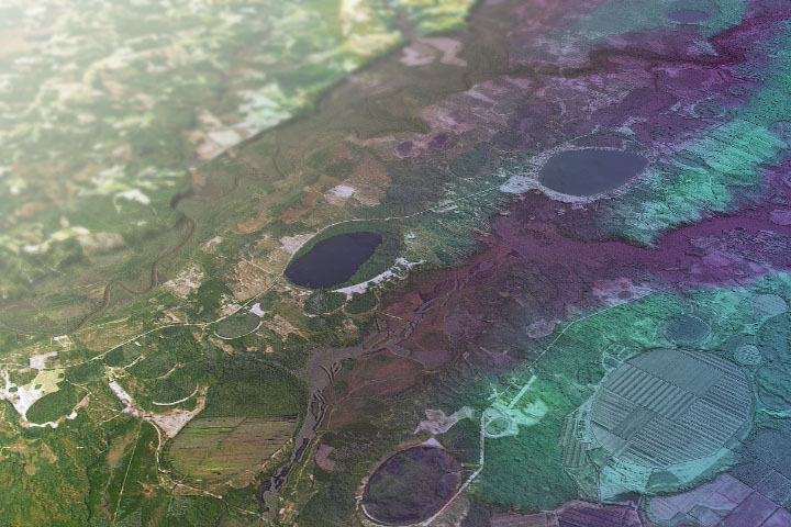
On October 3, 2017, the Operational Land Imager (OLI) on Landsat 8 acquired natural-color imagery of Gros Morne National Park. The UNESCO World Heritage site covers 1,800 square kilometers (690 square miles) in the Great Northern Peninsula of western Newfoundland. A detailed view of the Tablelands, in the southern portion of the park, is below.
Gros Morne provides some of the world’s best exhibits of the process of plate tectonics. The park contains a portion of the Long Range Mountains, a subrange of the Canadian Appalachians that dates back to around 1.2 billion years ago, when present-day North America collided with another continent. Those mountains have since eroded and left behind the gneiss and granite peaks of the Long Range. The park contains some of the tallest peaks of the Long Range mountains, including Big Level and Gros Morne Mountain (French for “great somber”).

The Tablelands, located on the south end of the park, are considered one of its most striking features. The flat-topped, rust-colored land is rich with peridotite rock from the upper part of Earth’s mantle. The rock was thrust towards the surface around 500 million years ago through a process known as subduction. When two plates on Earth’s crust collide, one is often pushed back (subducted) toward the mantle. Standing out amid the lush green park, the yellowish-red Tablelands played a crucial role in confirming the theory of plate tectonics.
The Canadian Space Agency has also studied the area to aid in the search for life beyond Earth. Scientists study how microscopic life forms can survive in the iron-rich Tablelands to better understand how they might survive on the extreme environment on Mars.
Gros Morne National Park also features some recent geologic history at the Western Brook Pond. The freshwater fjord was carved by advancing glaciers tens of thousands of years ago during the most recent ice age. After the glaciers melted and receded, the land rebounded and cut off the outlet from the sea. Saltwater was slowly and naturally flushed from the 30-kilometer (20-mile) long pond. Today, the fjord is surrounded by steep rock walls up to 600 meters (2,000 feet) high and contains nearly pure fresh water. The setting is a favorite for photographers.
Today, the park is protected by the Canada National Parks Act. One of the biggest natural threats to the park is a large moose population, which is five to 20 times higher here than in other parts of Canada. Introduced into the area about 100 years ago, the hungry population has eaten through large portions of the boreal forest and hindered regrowth.
NASA Earth Observatory images by Lauren Dauphin, using Landsat data from the U.S. Geological Survey. Story by Kasha Patel.