
Today’s Image of the Day is from our feature story: Trailing the Pacific Crest from Space.
Many hikers are lured to California’s Mount Whitney each year by the desire to stand atop the tallest peak in the continental United States. There’s more than one way to approach the 4421-meter (14,505-foot) summit in the Sierra Nevada. But each has its challenges: rapid elevation gain, rugged topography, and brutal weather can test even the most seasoned climbers.
A popular approach is from the eastern side of the range via the Mount Whitney Trail (assuming you win a permit in the Mount Whitney Lottery). A 200-mile drive north from Los Angeles puts you in Lone Pine, a small town in Owens Valley. The valley is visible at the bottom of this photograph, which shows the Sierra Nevada and Mount Whitney as observed from the east on December 19, 2018, by an astronaut on the International Space Station.
The Owens River is visible as a thin, dark line winding along the valley floor. Snowmelt helps feed the river, which in turn feeds an aqueduct system (not visible) that supplies water to Los Angeles. In the early 20th Century, water was diverted from Owens Lake and left the lakebed mostly dry (visible to the bottom-left).
The drive west from Lone Pine winds through the Alabama Hills, an area of deeply weathered rock formations near the range’s eastern foothills. Continuing on to Whitney Portal, which serves as the trailhead for the Mount Whitney Trail, you gain 4,600 feet of elevation from the valley, leaving about 6,000 feet of elevation to the summit. Extremely fit and prepared hikers can make the climb and back in a single day, although the quick ascent from the valley means altitude sickness is always a risk. And depending on winter snowfall totals, early season hikers might have to turn back due to impassable conditions.

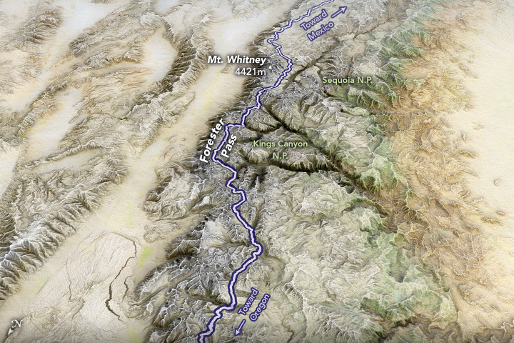
Hikers looking for a longer excursion can approach Mount Whitney from the western side through the Sierra Nevada backcountry. The Pacific Crest Trail (PCT), a long-distance hiking trail that runs 2,650 miles from Canada to Mexico, winds through the range. A segment of the trail (purple) is shown in the map above, which was made from natural-color imagery from NASA’s MODIS Blue Marble and draped over an elevation model from the Shuttle Radar Topography Mission.
Heading south on the PCT, hikers cross Forester Pass—the highest point of the Pacific Crest Trail at 13,153 feet. Hikers can then detour from the PCT toward the east on the John Muir Trail. The trail eventually turns back north and merges with the Mount Whitney Trail for the last few rugged miles toward the summit. The detour only takes a day, but PCT thru-hikers still face a long journey through Southern California.
NASA Earth Observatory image by Joshua Stevens, using MODIS/Blue Marble Next Generation data and topographic data from the Shuttle Radar Topography Mission (SRTM). Astronaut photograph ISS050-E-17326 was acquired on December 19, 2016, and is provided by the ISS Crew Earth Observations Facility and the Earth Science and Remote Sensing Unit, Johnson Space Center. Story by Kathryn Hansen.