
| Landsat Ground System | |||

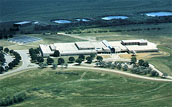
The Landsat ground system includes a spacecraft control center, ground stations for uplinking commands and receiving data, a data handling facility and a data archive developed by the Goddard Space Flight Center, Greenbelt, MD., in conjunction with the U.S. Geological Survey (USGS) EROS Data Center (EDC), Sioux Falls, SD. These facilities, augmented by existing NASA institutional facilities, will communicate with Landsat 7, control all spacecraft and instrument operations, and will receive, process, archive, and distribute ETM+ data. The primary ground station, the data handling facility and archive are located at the EROS Data Center and will fall under USGS management following launch and on-orbit activation of the satellite. NASA will manage flight operations from the control center at the Goddard Space Flight Center until October 1, 2000, when responsibility for flight operations transfers to the USGS as well. The ground system will be able to distribute raw ETM+ data within 24 hours of its reception at the EROS Data Center. The ground system at the data center will be capable of capturing and processing 250 Landsat scenes per day and delivering at least 100 of the scenes to users each day. All 100 of these scenes can be radiometrically corrected to within five percent and geometrically located on the Earth to within 820 feet (250 meters). Uncorrected data that is ordered will contain sufficient information to allow a user to do the correction. Data captured will routinely be available for user ordering within 24 hours of its receipt at the EROS Data Center. The user will be able to query metadata and image browse data from the archive electronically to determine if it contains suitable information. If so, the data can be ordered and delivered either electronically or in a digital format by common carrier. next: Calibration and Validation
|

Landsat 7 | ||