

by Steve Graham
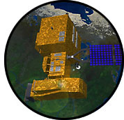
During the summer of 1993, NASA scientists teaming with academic researchers conducted a far-ranging and historic study that concluded the rate of tropical deforestation had declined from the 1970s, but continued to be a concern along the Brazilian Amazon Basin. The data used by the researchers came from the Landsat satellites and covered the 10-year period from 1978-1988. The latest mission in the Landsat series - Landsat 7 - is part of NASA's Earth Science Enterprise (ESE) and is being built to continue the flow of global change information to users worldwide. Scientists use Landsat satellites to gather remotely sensed images of the land surface and surrounding coastal regions for global change research, regional environmental change studies and other civil and commercial purposes. No other current or planned remote sensing system, public or private, fills the role of Landsat in global change research or in civil and commercial applications. Landsat 7 will fulfill its mission by providing repetitive, synoptic coverage of continental surfaces; spectral bands in the visible, near-infrared, short-wave, and thermal infrared regions of the electromagnetic spectrum; spatial resolution of 30 meters (98-feet); and absolute radiometric calibration. No other current or planned remote sensing system matches this combination of capabilities. Continuation of these capabilities is required for several reasons. The repetitive, broad-area coverage is needed for observation of seasonal changes on regional, continental and global scales. Other systems afford frequent global coverage, but none provide this global coverage at the 30-meter (98-feet) spatial resolution of the Landsat Thematic Mappers. Unlike the ocean and atmosphere, characterizing the land surface is distinguished by high spatial frequency processes that require a high spatial resolution. Both man-made (deforestation) and natural changes (glacial recession) are often initiated at scales requiring high resolution for early detection. The Landsat 7 system will offer the unique capability to seasonally monitor important small-scale processes on a global scale, such as the inter- and intra-annual cycles of vegetation growth; deforestation; agricultural land use; erosion and other forms of land degradation; snow accumulation and melt and the associated fresh-water reservoir replenishment; and urbanization. The other systems affording global coverage do not provide the resolution needed to observe these processes in detail and only the Landsat system provides a 26-plus year record of these processes. next: Scientific Objectives
|

Landsat 7
More Landsat 7 News |