| Mission Facts | |||
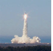
Landsat 7 launched on April 15, 1999 from the Western Test Range aboard a Delta-II expendable launch vehicle. At launch, the satellite weighed approximately 4,800 pounds (2,200 kilograms). The spacecraft is about 14 feet long (4.3 meters) and 9 feet (2.8 meters) in diameter. It consists of a spacecraft bus, being provided under a NASA contract with Lockheed Martin Missiles and Space in Valley Forge, PA., and the Enhanced Thematic Mapper Plus (ETM+) instrument, procured under a NASA contract with Raytheon (formerly Hughes) Santa Barbara Remote Sensing in Santa Barbara, Calif. The ETM+ instrument is an eight-band multispectral scanning radiometer capable of providing high-resolution imaging information of the Earth's surface. It detects spectrally-filtered radiation at visible, near-infrared, short-wave, and thermal infrared frequency bands from the sun-lit Earth in a 115 mile (183 kilometer)-wide swath when orbiting at an altitude of 438 miles (705 kilometers). Nominal ground sample distances or "pixel" sizes are 49 feet (15 meters) in the panchromatic band; 98 feet (30 meters) in the 6 visible, near and short-wave infrared bands; and 197 feet (60 meters) in the thermal infrared band. A Landsat World-Wide-Reference system has catalogued the world's landmass into 57,784 scenes, each 115 miles (183 kilometers) wide by 106 miles (170 kilometers) long. The ETM+ will produce approximately 3.8 gigabits of data for each scene, which is roughly equivalent to nearly 15 sets of encyclopedias at 29 volumes per set. The satellite will orbit the Earth at an altitude of approximately 438 miles (705 kilometers) with a sun-synchronous 98-degree inclination and a descending equatorial crossing time of 10 a.m. The orbit will be adjusted upon reaching orbit so that its 16-day repeat cycle coincides with the Landsat Worldwide Reference System. This orbit will be maintained with periodic adjustments for the life of the mission. A three-axis attitude control subsystem will stabilize the satellite and keep the instrument pointed toward Earth to within 0.05 degrees. A silicon cell solar array, nickel hydrogen battery power subsystem will provide 1,550 watts of load power to the satellite. A communications subsystem will provide two-way communications with the ground. The command uplink and the housekeeping telemetry downlink will be via S-band while all the science data will be downlinked via X-band. A command and data handling subsystem will provide for commanding, data collection, processing and storage. A state-of-the-art solid state recorder capable of storing 380 gigabits of data (100 scenes) will be used to store selected scenes from around the world for playback over a U. S. ground station. In addition to stored data, real-time data from the Enhanced Thematic Mapper Plus can be transmitted to cooperating international ground stations and to the U.S. ground stations.
next: Landsat Ground System
|
Landsat 7 | ||
