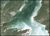
Chetumal Bay lies on the Border between Mexico and Belize. To the east of the bay, Ambergris Cay connects the Belize Barrier Reef to the Yucatan Peninsula. The north of the island is Bacalar Chico Marine Reserve. Here, the barrier reef comes very close to the east side of the island. In 1998, reefs in Belize were hit by two major events that led to heavy coral mortality: El Niño-related coral bleaching and Hurricane Mitch.
Published Oct 28, 2001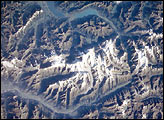
The Bernese Alps form the centerpiece of this late summer view of Switzerland; Jungfrau (4158 m), Moench (4089 m), and Eiger (3970 m) are among the higher peaks of the Central Alps. North of the range is the city of Interlaken, flanked by the Thune See and Brienzer See (lakes); the long, straight-segmented valley of the Rhone lies to the south.
Published Oct 21, 2001
This image represents, for its time, the greatest detail of the Giza plateau captured from a human-occupied spacecraft.
Published Oct 14, 2001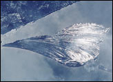
Sand ridges (cheniers) sweep in bands across St. Vincent Island, about 120 kilometers southwest of Tallahassee, Florida. These ridges have accumulated over time in the Apalachicola River delta complex. During high flow, the river delivers abundant sediment to the delta; as flow wanes the stream drops its load of coarser material around the channel mouth, to be redistributed primarily by waves. Variations in sediment supply and wave energy result in alternating bands of sand and mud. The crew of Space Shuttle 102 used the reflection of the sun off water that lies in the swales between ridges to emphasize the variable topography of the cheniers. Similar draping arrays of sand ridges and spits can be seen on the Po and Ebro river deltas of Italy and Spain, respectively.
Published Oct 7, 2001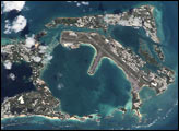
Along the south shore of Bermuda, waves break continuously along algal/vermetid reefs (composed of algae and molluscs, not coral), forming “boilers.” Boilers are named because the continuous breaking of waves makes it look as if the sea is boiling. This photograph taken from the International Space Station shows the eastern half of the main islands of Bermuda. Land use is about 6 percent cropland, 55 percent developed and 34 percent rural. Reflective white-colored areas are buildings and other developments surrounded by green areas of vegetation. St. David’s Island is also home to the airport, with runways built out into Castle Harbour.
Published Sep 30, 2001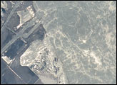
Astronauts aboard the Space Shuttle Discovery used the sunglint off the surface of the Mediterranean Sea to reveal biogenic films on the ocean surface (“Biogenic film” refers to a thin layer of biologically-produced film resting on the surface.). The films dampen surface capillary waves, creating brighter and darker reflections, which, in turn, trace the complex surface water movements along the coast. The sunglint also highlights coastal features (jetties, submerged costal areas) near the Port of Suez.
Published Sep 23, 2001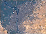
Astronaut photographs from the Gemini era and from the space shuttle reveal tremendous growth.
Published Sep 16, 2001
Shuttle astronauts frequently track Saharan dust storms as they blow from north Africa across the Atlantic Ocean. Dust palls blowing from Africa take about a week to cross the Atlantic. Recently, researchers have linked Saharan dust to coral disease, allergic reactions in humans, and red tides. The top photograph, a classic image showing African dust over the Caribbean, was taken at a time when few scientists had considered the possibility. The image was taken by Space Shuttle astronauts on July 11, 1994. This photograph looks southwest over the northern edge of a large trans-Atlantic dust plume that blew off the Sahara desert in Africa. In this view, Caicos Island in the Bahamas and the mountainous spines of Haiti are partly obscured by the dust. Closer to the foreground, (about 26 degrees north latitude), the skies are clear.
Published Sep 9, 2001
An astronaut on the Space Shuttle photographed several wildfires burning in California in August 2001.
Published Sep 2, 2001
At the junction of the Chobe and Zambezi Rivers, Botswana, increasing elephant populations are having large impacts on local vegetation. Scientists working in the region used spectral analysis of an astronaut photograph digitized from film to identify areas where woodland vegetation had been heavily damaged by the elephants. The technique used the analysis of texture of the red band (or channel) in the image.
Published Aug 26, 2001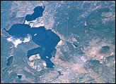
The Klamath Basin, on the California-Oregon border, had been in the news because of water shortages due to the drought in the United States’ Pacific Northwest. Diverse interest groups have come into conflict over the limited availability of Klamath Project water. In order to protect endangered Sucker Fish and threatened Coho Salmon in Upper Klamath Lake, the U.S. Bureau of Reclamation cut off the flow of irrigation water to farmers in the project in April 2001.
Published Aug 19, 2001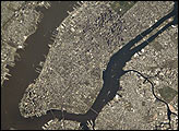
It was a fine spring day on April 28, 2001, in New York City when the Expedition 2 crew of Space Station Alpha acquired this digital photograph. This ESC image was taken of Manhattan using an 800 mm lens (see inset) from an orbit altitude of 383 km. This particular lens can achieve spatial resolutions less than 6 meters.
Published Aug 12, 2001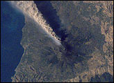
The record of historical volcanism of Mt. Etna is one of the longest in the world, dating back to 1500 BC.
Published Aug 4, 2001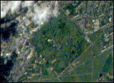
Greenwich is situated on the south shore of a sharp bend in the River Thames, just southeast of the City of London and is part of Greater London. Here is located the world famous Royal Observatory where the Prime Meridian, dividing East and West Longitude, was defined by international agreement in 1884.
Published Jul 29, 2001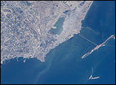
Baku is Azerbaijan’s major city, and the oil capital of the Caspian region. This detailed view taken by the Expedition 2 crew on the International Space Station shows details of the city, including the extensive port facilities, and part of the large web of offshore oil platforms in the Caspian Sea.
Published Jul 22, 2001
Mayon volcano is the most active volcano in the Philippines, located just north of the coastal town of Legaspi in southern Luzon about 325 km southeast of Manila. Mayon is a near-perfect cone; its steep, forested slopes look rather like a bull’s eye when viewed from above.
Published Jul 15, 2001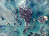
The compact Italian city of Venice with its renowned canals is situated on a small, fish-shaped island in the Laguna Veneta at the northwest corner of the Adriatic Sea. In this photo taken from the International Space Station by the Expedition 1 Crew on February 21, 2001, one can see part of the causeway connecting the city to the mainland. The sinuous Canal Grande bisecting the city is easily visible in this scene as is the larger Canal Giudecca to the west, which leads to the port facilities on the northwestern end of the island. For centuries, the low-lying city has successfully coped with the three-foot tidal range experienced at this end of the Adriatic Sea, and the series of barrier islands has offered some protection from storm waves. However, a combination of both regional land subsidence and recent slight rises in sea level pose a significant threat this historic city and its priceless art treasures.
Published Jul 8, 2001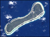
These two images of the Tuamotu Archipelago, French Polynesia, illustrate diversity in the morphology of atolls, one of the major types of coral reef formations. A typical atoll structure is a lagoon surrounded by a closed rim of cays and shallow spillways that control the exchange of water between the ocean and the lagoon. However, like human beings, this general scheme may vary according to the history of each individual atoll, resulting in a high diversity of morphology, especially for small atolls. The two neighboring atolls shown here have some unique features. What was a lagoon on Nukutavake (19°17′ S 138°48′ W, 6.2 km²) is now dry and completely covered by vegetation. Pinaki (3.54 km²) has a drying shallow lagoon still connected to the ocean via a single narrow spillway. The variation of morphology implies that each atoll may have a different equilibrium between ocean, lagoon, and land ecosystems.
Published Jul 1, 2001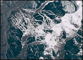
The snow-covered ski runs of Vail, Colorado, look like white ribbons in contrast to the dark green forests of the Rocky Mountains. This detailed image is part of a larger view of area ski resorts photographed by the STS-100 Space Shuttle crew in April, 2001.
Published Jun 24, 2001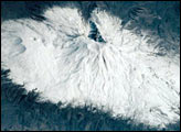
Mount Ararat (16,940 feet; 5165 meters) is the largest volcano in Turkey. Although not currently active, its most recent eruption has probably been within the last 10,000 years. It is located in extreme northeastern Turkey, near the borders with Iran and Armenia. Southwest of the main peak lies Little Ararat (12,877 feet; 3896 meters). Ahora Gorge is a northeast-trending chasm dropping 6000 feet from the top of the mountain and was the focus of a major earthquake in 1840. A number of claims by different explorers to have found remnants of Noah’s Ark on Mt. Ararat have led to continuing expeditions to the mountain, many of which have focused their searches on the gorge area.
Published Jun 17, 2001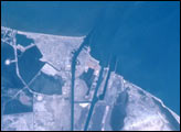
This time series of photographs of the Mediterranean coast near the Suez Canal shows ten years of changes associated with two of Egypt’s “Mega” Development Projects. At the mouth of the canal, a large auxiliary channel has been formed as part of a new central hub port and industrial zone, known as the East Port-Said Project. Further south, the effects of the Al-Salam (El Salam or “Peace”) Canal and North Sinai Agricultural Development Program can be seen as desert is converted to irrigated agriculture.
Published Jun 10, 2001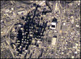
A series of digital photographs of Houston illustrates the new detail being obtained for cities around the world by crewmembers on the International Space Station. This image, captured on 17 December 2000 centers on the downtown region and shows extensive detail of streets, parks and major buildings.
Published Jun 3, 2001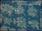
The area east of Santa Cruz was originally dry tropical forest.
Published May 27, 2001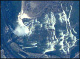
The Niagara River forms the U.S.-Canadian Border and allows Lake Erie to drain northwest into Lake Ontario. Lake Ontario is about 100 m lower than Lake Erie; the Falls and the rapids account for most of the elevation difference. The energy derived from water falling over the falls, with average total flows of 750,000 U.S. gallons (2.8 million liters) per second, fuel multiple power plants on the river. Power Plants downstream from the plant generate 4.4 million kilowatts of power for both Ontario and New York.
Published May 20, 2001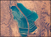
The complex of Jordanian salt evaporation ponds at the southern end of the Dead Sea has expanded significantly over the past dozen years. The western margin of the salt ponds marks the Jordan-Israel border. In August 1989, when the crew of Space Shuttle mission STS-28 photographed the region, the northern extension did not exist and the large polygonal ponds in the northwestern and northeastern sectors had not been subdivided. In the view taken by the STS-102 crew in March 2001, one can see that there has also been expansion at the southeastern end, and that levees now segment the northeastern wedge into four ponds.
Published May 13, 2001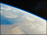
Dust blowing off the Gobi desert eastward across the China toward the Pacific Ocean is a common event in April. Space Shuttle astronauts have photographed these dusts storms several times. These photographs, taken by astronauts on April 25, 1990, show a thick blanket of dust that entirely obscures the southern half of the Korean Peninsula. The dust is being transported from west (left) to east (right). The mountainous spine of the peninsula induces gravity waves in the dust cloud on the downwind (east) side.
Published May 6, 2001
As the Space Shuttle Atlantis passed over southern Egypt in mid-March 2001, the STS-102 astronauts were able to document new flooding in the Toshka region west of Lake Nasser. The formation of the Toshka Lakes in southern Egypt is part of Egypt’s New Valley Project. The flooding of the region has been monitored by astronauts since 1998, and continues to show rapid changes.
Published Apr 22, 2001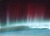
Reds and greens dominate this view of the northern lights as photographed from the Space Shuttle in May 1991.
Published Apr 15, 2001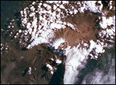
Mt. Kilimanjaro (Tanzania), the highest point in all Africa, was photographed by the crew of Space Shuttle mission STS-97 on December 2, 2000. Kilimanjaro (Kilima Njaro or “shining mountain” in Swahili) is capped by glaciers on its southern and southwestern flanks.
Published Apr 8, 2001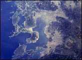
The Isahaya Bay Reclamation project separated approximately 3,000 hectares of tidal flats from the Ariake Sea in 1997. This photograph was taken from the Space Shuttle on April 27, 1998, a year after the sea wall separating Isahaya Bay from the rest of the Ariake Sea was closed.
Published Apr 1, 2001