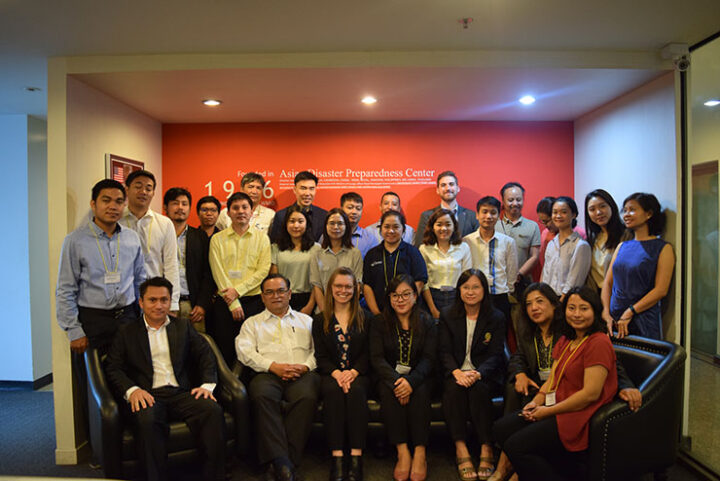
My colleague, Tim Mayer, and I just made it home from leading a three-day workshop focused on estimating forest stand height using L-band Synthetic Aperture Radar (SAR) data. Hosted by the SERVIR-Mekong hub at the Asian Disaster Preparedness Center (ADPC), this activity is part of the SERVIR and SilvaCarbon forest monitoring SAR Handbook initiative, which provides researchers with tools to use SAR for forest monitoring and biomass estimation.

Located in Thailand’s Chao Phraya river delta, Bangkok is a bustling hub with over eight million residents covering 600 square miles (1,554 square kilometers). The city contains everything from urban shopping malls to mangrove swamps!
Generally, remote sensing researchers interested in tropical regions have a difficult time finding satellite imagery with little to no clouds. L-band SAR, with a wavelength of about ~25 cm, penetrates through clouds, providing a unique opportunity to see through forest canopies and enabling measurements of the limbs and trunks of trees from space. Forest height and density reflect the forest age and health. In addition, forest height can be used to estimate Above Ground Biomass (AGB), and the amount of carbon sequestered by vegetation. This is important to organizations like the United Nations REDD+ Programme, which works with partner countries to reduce greenhouse gas emissions from deforestation and degradation. In South and Southeast Asia, the SERVIR-Mekong and SERVIR-Hindu Kush Himalaya hubs support these partners in deriving estimates for forest monitoring and evaluation purposes.

Each morning, I boarded the train and rode two stops to the workshop. Bangkok has grown rapidly and organically, out of necessity. In order to reduce pollution levels, public transportation has expanded and is an efficient way to move around the city.

The workshop participants came from governmental departments and universities, including the Ministry of Environment (Cambodia); Forest Inventory & Planning Institute (FIPI); Institute of Forest Ecology & Environment (Vietnam); Forest Inventory & Planning Division (Laos); National University of Laos; Department of National Parks, Wildlife & Plant Conservation (DNP, Thailand); Geo-Informatics & Space Technology Development Agency (GISTDA, Thailand); and the Forest Research & Training Centre (FRTC, Nepal). In addition, members of SERVIR from both the Mekong and Hindu Kush Himalaya regions attended.
Over 20 representatives from six countries (Thailand, Nepal, Myanmar, Vietnam, Cambodia and Laos) participated in the workshop. The attendees had a range of expertise, with backgrounds in engineering, geography, computer science, remote sensing, forestry and Geographic Information Systems (GIS). Most of the attendees support forest monitoring and reporting activities as part of their work. Participants left with the tools needed to explore how this technique can be integrated into their work with land classification, carbon pool estimation, and forest monitoring.

Participants engaged in hands on exercises using ALOS PALSAR-1 L-Band SAR data from the Japan Aerospace Exploration Agency (JAXA) and LiDAR-based tree heights to estimate forest stand height in central Maine, US. This exercise is available in Appendix C of the SAR Handbook.
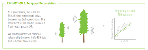
We focused on the temporal decorrelation method of estimating forest stand height (FSH) as described in the SAR Handbook chapter four by Paul Siqueira. Siqueira, Yang Lei, and other authors published a novel approach to estimate FSH above 10m in 2019. The temporal decorrelation method relies on the assumption that if a sensor captures two snapshots of the same area of forest at different times, the sensor will measure a change between the two scenes. On average, the taller the trees the more change the sensor will detect. The algorithm takes the relationship between known tree heights and the amount of change detected by the sensor, and applies that relationship to areas where no known tree height measurements exist in order to estimate forest stand height.

One method of estimating forest stand height is temporal decorrelation (Source: The SAR Handbook/Leah Kucera)
Participants left with a concrete understanding of how to apply these techniques to their own countries for MRV (Monitoring Reporting and Verification) and land classifications. One participant commented, “This training revolutionize[d] my concept of boring and complex coding to fun and powerful way[s] of analyzing Earth Observation data in an understandable way.” I look forward to working on improvements to the forest stand height estimation algorithm with the SERVIR network and building upon the relationships established during the workshop to estimate forest stand height in their respective countries. After the launch of NASA-ISRO Synthetic Aperture Radar (NISAR) mission in 2021, we will be able to adapt our methods to include NISAR’s current and more frequent global L-band SAR dataset.


Wow! Your article is very interesting this is exactly what I want to here I be reading some of your article for a while now and I think this one is the best I have ever read continue sharing this kind of good information because I am looking forward to read more of it. Thanks a lot for dropping this.