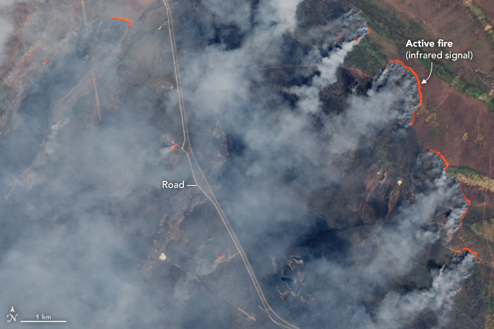


A large number of intense fires have spread across far eastern Russia this spring, shrouding the skies, roads, and forests in smoke. In just six days between May 7–13, 2018, Russian firefighters beat back 693 fires in 40 territories. Many of the fires were located in the Amur Oblast region in Siberia. Crews are still working to extinguish fires in the area.
These images of blazes in Amur Oblast were captured by Landsat 8 on May 7, 2018. Natural-color data (bands 4–3–2) are overlaid with infrared data (bands 6 and 5) to reveal still-burning hot spots.
A dry, warm winter has set the stage for a difficult wildfire season in 2018 in Russia. Forest fires are common in this heavily forested region, and the season usually starts in April or May. Farmers in this area also burn old crops to help clear fields and replenish the soil with nutrients; such fires occasionally burn out of control. Amur Oblast has so far experienced more fires per month this year than any since 2008, according to the Global Fire Emissions Database.
Scientists have observed a spike in atmospheric carbon dioxide levels and aerosols since the recent Siberian fires started raging. Aerosols, tiny airborne particles in the smoke, have been carried by weather fronts across the Pacific Ocean and into Canada, according to NASA’s Ozone Mapping and Profiler Suite.
The large quantities and long-distance transport of these aerosols could indicate a pyrocumulus event. Towering pyrocumulus clouds are formed by heat from fire, rather than evaporation from sun-warmed ground. They tend to loft smoke high into the atmosphere, where it can be swept away by upper–level winds. Also, high levels of carbon monoxide are forecasted to reach the Arctic, according to Mark Parrington, a senior scientist at the Copernicus Atmosphere Monitoring Service of the European Centre for Medium–Range Weather Forecasts.
NASA Earth Observatory images by Joshua Stevens, using Landsat data from the U.S. Geological Survey. Story by Kasha Patel.