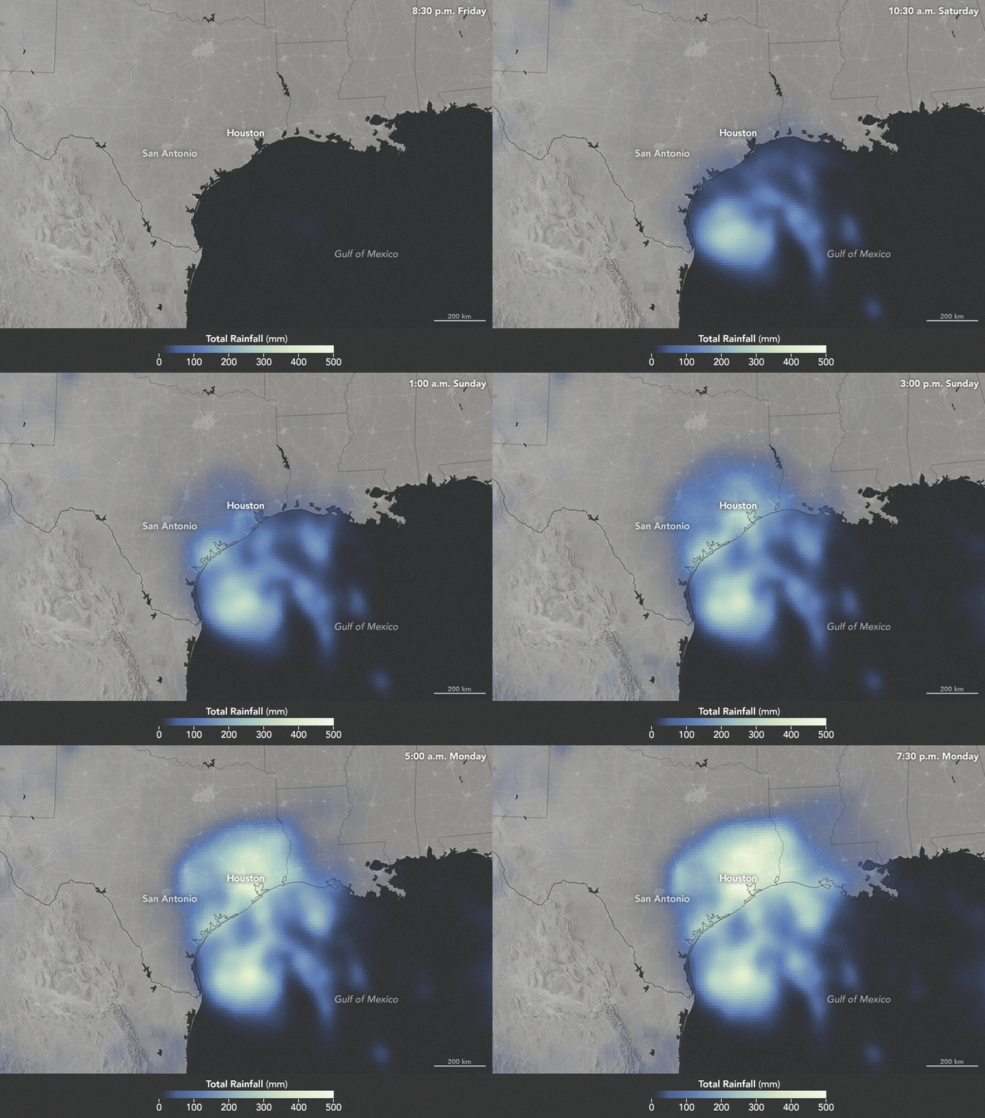


Torrential rains from Hurricane Harvey (now a tropical storm) continue to batter the flood-ravaged Texas, and the threat is now stretching into southwestern Louisiana. The sluggish storm—moving just 4 kilometers (2 miles) per hour at times—has been pulling warm, moist air from the Gulf of Mexico to fuel tremendous rainfall over land.
The animation above depicts satellite-based measurements of rainfall from 7:30 p.m. Central Daylight Time on August 25 to 7:30 p.m. on August 28, 2017. The brightest areas reflect the highest rainfall amounts, with many places receiving 500 millimeters (20 inches) or more during this period (the top of our scale). The measurements are a product of the Global Precipitation Measurement (GPM) mission, which is a partnership between NASA, the Japan Aerospace Exploration Agency, and five other national and international partners.
These rainfall totals are regional, remotely-sensed estimates. Each pixel shows 0.1 degrees of the globe (about 7 miles at the equator), and the data are averaged across each pixel. Individual ground-based measurements within a pixel can be significantly higher or lower than the average. Forecasters called for some locations to receive as much as 50 inches of rain.
According to the National Weather Service, a station southeast of Houston is nearly there. The rain gauge at “Mary’s Creek at Winding Road” recorded 49.2 inches from 12 a.m. on August 25 to 9:20 a.m. on August 29. The amount breaks the record for rainfall measured from a tropical system in the continental United States, which was previously set in 1978 in Medina, Texas, by Tropical Cyclone Amelia. See a summary of storm totals by clicking here.
Data for the animation comes from the Integrated Multi-Satellite Retrievals for GPM (IMERG), a product of the GPM science team. IMERG compiles precipitation estimates from passive microwave and infrared sensors on several satellites, as well as monthly surface precipitation gauge data, to provide precipitation estimates between 60 degrees North and South latitude.
Harvey made landfall in Texas as a category 4 storm on August 25. As of August 29, the National Hurricane Center was calling for 6 to 12 more inches of rain to fall over parts of Texas and Louisiana. Storm surges and ocean swells continued to affect coastal areas, and the development of tornadoes remained possible.
NASA Earth Observatory image by Joshua Stevens, using IMERG data provided courtesy of the Global Precipitation Mission (GPM) Science Team's Precipitation Processing System (PPS). Story by Kathryn Hansen.