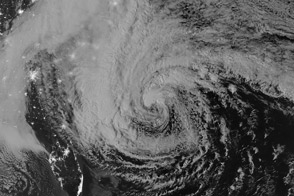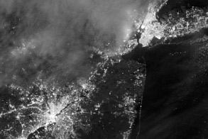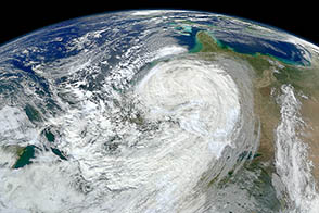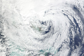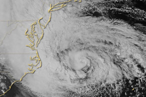
On October 29, 2012, Hurricane Sandy approached the densely populated U.S. East Coast. An estimated 60 million Americans were expected to be affected by rain, wind, snow, or ocean surges from the storm. The Visible Infrared Imaging Radiometer Suite (VIIRS) on the Suomi NPP satellite acquired this natural-color image of Sandy at 1:35 p.m. Eastern Daylight Time (17:35 Universal Time) on October 29.
At 2:00 p.m. EDT on October 29, the U.S. National Hurricane Center (NHC) reported that Sandy was located about 110 miles (180 kilometers) southeast of Atlantic City, New Jersey, and about 175 miles (285 kilometers) south-southeast of New York City. The storm had maximum sustained winds of 90 miles (150 kilometers) per hour. The storm was moving toward the northwest at about 28 miles (44 kilometers) per hour. The NHC stated that Sandy could transition into a wintertime low-pressure system later in the day, but cautioned that this would not weaken the storm prior to landfall.
The NHC forecast that Hurricane Sandy would come ashore on the evening of October 29, along the coast of southern New Jersey or Delaware. They warned of multiple hazards associated with the storm. Hurricane-force winds were predicted for the Mid-Atlantic States, including New York City, with tropical storm-force winds from Virginia to Canada. A storm surge, combined with astronomically high tides (at full Moon), promised to flood coastal areas with waters as much as 11 feet (3 meters) above normal. Sandy was forecast to drop as much as 8 inches (20 centimeters) of rain, and the mountains of Appalachia were expected to receive up to 3 feet (1 meter) of snow.
The NHC urged citizens to consult their local National Weather Service forecast offices for more information. Government officials urged people to heed evacuation warnings, and hundreds of thousands fled their homes by October 29, CNN reported. More than 100,000 customers in seven states had already lost electrical power. In the days leading up to the storm, as residents stocked up on supplies and utility companies called in reinforcements from across the country, the U.S. Geological Survey deployed more than 150 storm-surge sensors along the Atlantic Coast to monitor Sandy’s effects in real time.
NASA Earth Observatory image by Jesse Allen, using Suomi NPP VIIRS data provided by Cooperative Institute for Meteorological Satellite Studies (CIMSS). Suomi NPP is the result of a partnership between NASA, NOAA and the Department of Defense. Caption by Michon Scott.