
Benefits to SocietyMany of Terra’s achievements benefit society. For example, Terra data have helped improve scientists’ ability to predict the weather. Terra’s ability to track the speed, direction, and height of clouds allows scientists to accurately measure how hard and which way the wind is blowing over areas where they had precious little data before. Terra’s Multi-angle Imaging Spectroradiometer (MISR) measures of wind heights over the Pacific Ocean have proven more accurate than our best operational weather satellites. (Please read Tracking Clouds for more details.) |
|||

|
|||
|
Two years ago meteorologists at the European Centre for Medium-Range Weather Forecasts (ECMWF) began using Terra MODIS data to track clouds over the Arctic Circle. Before Terra, scientists had to make mostly educated guesses about wind strength and direction. But given Terra’s updates every 99 minutes over the Arctic, scientists are able to feed their computers with much more timely and accurate information. The result is a 3-hour advance in the accuracy of their forecasts. This advance may not seem like much but one expert equates that to a whole year’s worth of research and development by the ECMWF. (Please read Polar Wind Data Blow New Life into Forecasts for more details.) Terra has helped weather forecasters in other ways too. Before Terra, scientists made assumptions about how much sunlight gets reflected by the surface in seldom-measured parts of the world, such as the Sahara Desert. Today Terra provides scientists with much more accurate information on Earth’s albedo (or reflected sunlight) over areas where before they could only make educated guesses. The end result is improved weather forecasts in Northern Africa, the Arabian Peninsula, and across great expanses of the mostly uninhabited boreal forests of North America and Asia. (Please read Measuring Earthshine: How New Terra Data are Improving Weather and Climate Forecast Models for more details.) |
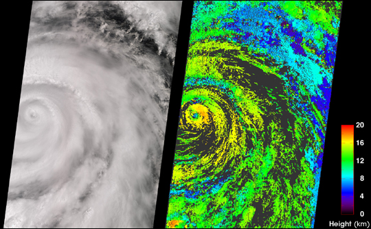
A classical intense hurricane is shown in this view of Juliette, captured by the Terra MISR instrument on September 26, 2001. On the left is a true-color image produced by MISR’s nadir (vertical-viewing) camera. Impressive spiral arms wrapped around the eye are apparent. Several areas of convective clouds can be discerned along the arms. On the right is the cloud-top height field derived using automated computer processing of the data from multiple MISR cameras. Relative height variations are well represented, such as the clearing within the storm’s eye. (NASA image courtesy Image courtesy NASA/GSFC/LaRC/JPL, MISR Team.) More information. | ||
|
Another of Terra’s benefits to society has been the development of natural hazard warning systems. A mission goal is to help humans avoid emerging hazards where possible, to reduce the impact of hazards where avoidance is not possible, and to more accurately assess the damage where and when natural disasters happen. The mission’s unique combination of sensors allows scientists worldwide to monitor fires, floods, severe storms, and volcanic activity in near real time. Today organizations all over the world use data from four different instruments aboard Terra as part of their ongoing efforts to monitor the causes and effects of natural hazards. Moreover, more than 80 receiving stations positioned around the world routinely and freely receive Terra data as it is broadcast live and continuously. These receiving stations push Terra data to more than 800 operational users for a wide range of research and practical science applications. “Timely data from the Terra satellite are being used to produce maps of where active fires are burning all over the world,” said Ranson. Used operationally by USDA Forest Service and the U.S. National Interagency Fire Center, Terra MODIS and ASTER data help firefighters develop strategies for fighting the fires as well as assessing the severity of the burns. (Please read From Space to the Outback and Satellites Aid Burned Area Rehabilitation for more details.) “This same technology also allows scientists to map the locations of volcanic hot spots all over the world,” continued Ranson. “Such information has great potential to save lives, not just for people living near active volcanoes, but also for commercial airlines that routinely fly near them.” |
The new MODIS albedo data product reveals in striking detail how widely varied the terrain is across Northern Africa and the Arabian Peninsula. The variation across the land’s surface affects how much solar radiation is absorbed and how much is reflected back up into the overlying atmosphere. This new data product should significantly improve weather forecast models for that region. This image was produced using data composited over a 16-day period, from April 7-22, 2002. (Image courtesy Elena Tsvetsinskaya, Boston University) More information. | ||