|
|||
On May 4, 2000, a prescribed fire on National Park Service land near Los Alamos,
New Mexico, was blown out of control by erratic, gusty winds. The fire exploded into nearby Santa Fe
National Forest, swept across lands at Los Alamos National Laboratory, and destroyed hundreds of homes
in the town of Los Alamos. Even as firefighters were struggling to contain the blaze, another problem
loomed in the minds of the people involved. Some of the burned land was in a watershed that fed into
canyons where the Los Alamos National Laboratory, birthplace of the atomic bomb, had buried potentially
radioactive waste before environmental regulations were as strict as they are today. What would happen
when the monsoon season began in less than two months and thunderstorms drenched the fire-charred
landscapes? |
|||
Answering that kind of question is the work of a multidisciplinary group of scientists and natural
resource management experts called a BAER team, for Burned Area Emergency Rehabilitation. Members can
comefrom several federal and state agencies and can consist of hydrologists, wildlife biologists,
archaeologists, soils scientists, landscape architects, geologists, ecologists, engineers, foresters,
botanists, and Geographic Information System (GIS) specialists. Usually on the ground before a fire is
even fully contained, a BAER team evaluates the burned area for threats to life, property or natural
resources due to post-fire flooding and erosion. |
Forest fires attract the most attention when they’re actively burning, but a threat remains after the flames have died down. After a fire, damaged vegetation, scorched underbrush, and soils that shed water can lead to severe erosion and flash floods. Scientists now use satellite data to aid rehabilitation teams in locating severely burned areas, helping to prevent post-fire disasters. (Photograph copyright Kari Brown, National Interagency Fire Center Image Portal) |
||
Why is flooding after a fire such a big threat? For one thing, flames consume leaf litter and decomposing matter on the ground that normally soak up water. Additionally, after a fire, the soil itself has the potential to become hydrophobic, or water repellant. Plants and trees have numerous protective chemicals with which they coat their leaves to prevent water loss. Many of these substances are similar to wax. Vaporized by the heat from fires, these substances disperse into the air and then congeal over the soil surface when the fire begins to cool. Like the wax on your car, these substances coat the soil, causing water to bead up and run off quickly. In general, the greater the fire intensity and the longer the fire’s residence time, the more hydrophobic the soil becomes. |
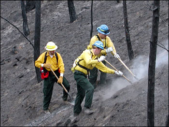
Burned Area Emergency Recovery (BAER) teams move in soon after a fire sweeps through. Composed of wildlife biologists, soil scientists, foresters, and other natural resource specialists, the teams are responsible for locating areas that are susceptible to post-fire erosion, and doing what they can to prevent soil loss and flooding. (Photograph courtesy Rob Sohlberg, University of Maryland) | ||
|
|||
In the short term, loss of vegetation and hydrophobic soil contribute to flash flooding and erosion—sometimes to the point of landslides. When fallen trees and other fire debris are added to the scenario, floods can become severe. Excessive rainwater can sweep ash and debris into streams and rivers, contaminating natural and manmade water sources. This past summer, the Hayman Fire in Colorado resulted in erosion problems that fed ash and sediment into Cheesman Reservoir, which supplies 15 percent of Denver’s water. Several other reservoirs were affected by the blaze as well. Humans aren’t the only ones affected. Mudslides resulting from the Missionary Ridge Fire near Durango, Colorado, washed mud and debris into the Animas River, killing hundreds of fish in the award-winning trout stream. |
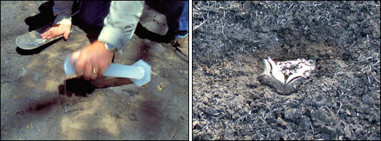
A hot fire can even change the composition of soil, making it hydrophobic. Hydrophobic soils repel water, which will bead up and quickly run downslope. Instead of being absorbed by vegetation and forest litter, rain in a severely burned area will stay on the surface, potentially causing floods, erosion, and mudflows. Assessing how hydrophobic the soil has become is an important BAER team activity. [Photographs courtesy USDA Forest Service (USDAFS) Agricultural Research Service (left) and Annette Parsons, USDAFS (right)] | ||
|
|||
Beyond this immediate cause for concern, water-repellant soil poses a longer-term problem for new plant growth. As seeds and undamaged plant structures try to regenerate in a burned area, they need water. But rainwater has difficulty soaking down into water-repellent soil, sometimes slowing the healing process in severely burned areas. In assessing such threats, BAER teams are under intense pressure: they must make an assessment report with seven days of a fire’s containment. If threats exist, such as the potential for a landslide on a fire-charred mountain slope to descend upon nearby homes, the team must include mitigation measures that can be carried out before the first damaging storm. In the case of the Cerro Grande Fire, those measures included the construction of a small dam in Pajarito Canyon to prevent any potentially radioactive-contaminated sediment from entering the watershed and being carried away from the site.
The data used in this study are available in one or more of NASA's Earth Science Data Centers. |
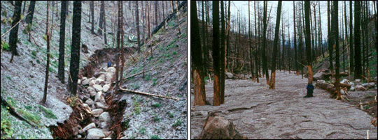
These photographs show the results of post-fire erosion. The boulder-filled channel (left) was created after the Cerro Grande fire. The eroded material was deposited further downstream (right). The water during the flood reached several feet higher, as shown by the trees stripped of bark. (Photographs courtesy John A. Moody, USGS Hydrologic and Erosional Responses of Burned Watersheds) | ||