The Earth Observatory has published its last Image of the Day on this website. Please join us on our new home at science.nasa.gov/earth/earth-observatory.
So what does a satellite imager measure to produce an image? It measures light that we see and light that we don’t see. Light is a form of energy—also known as electromagnetic radiation—that travels in waves. All light travels at the same speed, but the waves are not all the same. The distance between the top of each wave—the wavelength—is smaller for high-energy waves and longer for low-energy waves.
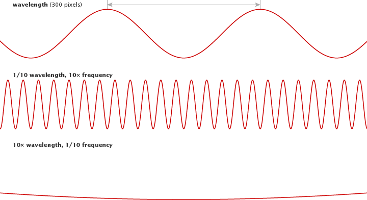
Visible light comes in wavelengths of 400 to 700 nanometers, with violet having the shortest wavelengths and red having the longest. Infrared light and radio waves have longer wavelengths and lower energy than visible light, while ultraviolet light, X-rays, and gamma rays have shorter wavelengths and higher energy.
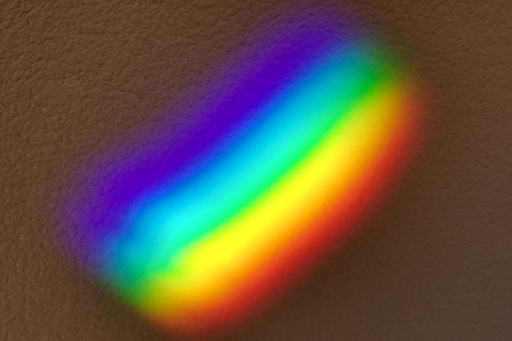
The spectrum of visible light stretches from violet (0.4 µm) to red (0.7 µm). (Photograph ©2013 Mathew Buckley.)
Most of the electromagnetic radiation that matters for Earth-observing satellites comes from the Sun. When sunlight reaches Earth, the energy is absorbed, transmitted, or reflected. (Absorbed energy is later re-emitted as lower-energy radiation.) Every surface or object absorbs, emits, and reflects light uniquely depending on its chemical makeup. Chlorophyll in plants, for example, absorbs red and blue light, but reflects green and infrared; this is why leaves appear green. This unique absorption and reflection pattern is called a spectral signature.
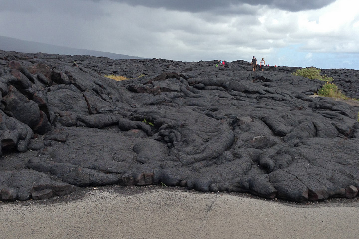
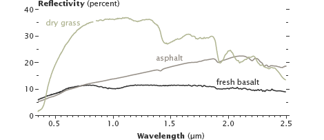
Varied land surfaces have distinct spectral signatures. Fresh basalt lava and asphalt reflect different amounts of infrared light, even though they appear similar in visible light. (Photograph ©2012 Robert Simmon. Figure by Robert Simmon, using data from the USGS Digital Spectral Library.)
Like Earth’s surfaces, gases in the atmosphere also have unique spectral signatures, absorbing some wavelengths of electromagnetic radiation and emitting others. Gases also let a few wavelengths pass through unimpeded. Scientists call these “atmospheric windows” for specific wavelengths, and satellite sensors are often tuned to measure light through these windows.
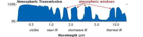
Atmospheric windows are regions of the spectrum where most light penetrates through the atmosphere, allowing satellites to view the Earth’s surface. (Figure adapted from Casey et al, 2012.)
Some satellite instruments also directly measure the energy emitted by objects. Everything gives off energy, usually in the form of heat (thermal infrared radiation). The hotter an object is, the shorter the peak wavelength it emits. At about 400°C (750° F)—the temperature of an electric stove burner set to high—the emitted light will begin to be visible. The colder an object is, the longer the peak wavelength it emits.
