
What is a Model Forest? | |||
To find out how a forest or a field of wheat influences weather or climate, modelers simulate the intricate interactions between land and sky. The goal, says NASA modeler Lahouari Bounoua, is to first understand how a single molecule of carbon dioxide is pulled into a leaf in exchange for oxygen and water vapor, and then to scale that interaction up until the model describes the impact of all Earth’s vegetation on its climate. To do this, modelers need to know specific biological and physical characteristics—modelers call them “biophysical parameters”—of the landscape, everything from leaf density, to root depth, to canopy height. Biophysical parameters change from landscape to landscape. |
|||
 |
|||
Steyaert, a climate and atmospheric scientist visiting NASA Goddard Space Flight Center from the U.S. Geological Survey, has spent much of the past decade mapping regional land cover and biophysical parameters for regional climate models. He has scoured books and other scientific literature to understand how the landscape of the past looked, and he reconstructed historical landscapes in the eastern United States for four snapshots in time: pre-colonial, 1850, 1920, and 1992. Then he asked NASA ecologist Robert Knox to help him develop the next generation of landscape data that would include not only landscape categories—like forest or farmland—but also historical biophysical parameters, the “real numbers” that regional climate models depend on. Having worked with climate modelers on a previous forest-mapping project and having spent a lifetime observing forests first hand, Knox knew that to understand the impact of land cover change on climate, you had to understand in detail how land use changes the biophysical nature of the forest: the way it disturbs the wind, reflects light, evaporates water, or cools the ground. All these changes, Knox understood, had to be represented by different numbers in climate models. |
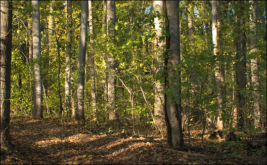
This young forest is crowded with trees of nearly the same age and size. The crowding and uniformity are signs that all the trees grew up together following a disturbance that eliminated competition from taller trees. The canopy in such forests is smooth. This smoothness means that a regrowing forest interacts with the atmosphere differently than an old-growth forest, and that could impact the weather. (Photograph by Robert Simmon.) | ||