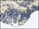
In early May 2008, Cyclone Nargis caused widespread flooding in Burma (Myanmar). Besides trying to assist the storm survivors, the international community also tried to determine the extent of flooding, but making such a determination can be difficult. Researchers at the University of Maryland’s Department of Geography developed a method of detecting floodwater by examining multiple sources of information to provide a better—though not perfect—picture of flooded areas.
Published May 16, 2008
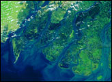
Though Yangon (Rangoon) escaped the total destruction that Cyclone Nargis brought to much of the rest of the Irrawaddy Delta in Burma (Myanmar), its southern suburbs were completely submerged on May 7, 2008.
Published May 9, 2008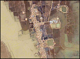
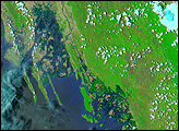
The first cyclone of the 2008 season in the northern Indian Ocean was a devastating one for Burma (Myanmar). Cyclone Nargis came ashore across the Mouths of the Irrawaddy and followed the coastline northeast. The entire coastal plain is flooded in the May 5 image. The fallow agricultural areas appear to have been especially hard hit.
Published May 6, 2008alert message
