

On July 22, 2016, an illegal campfire ignited a wildfire in Monterey County, California. The so-called Soberanes fire burned and smoldered for months and ultimately scorched more than 130,000 acres. But the fire had impacts beyond burned trees, destroyed property, and smoky air. After the fire, the areas of scorched soil became more vulnerable to flooding and erosion because there was no longer protective ground cover holding the soil in place.
Immediately after wildfires like Soberanes, Burned Area Emergency Response (BAER) teams waste no time in identifying at-risk areas and developing a recovery plan. But a quick response requires quick access to data, much of which comes from satellites. To streamline the effort, researchers created the Rapid Response Erosion Database (RRED), a joint collaboration between Michigan Tech, the NASA Applied Sciences Program, and the U.S. Forest Service Rocky Mountain Research Station.
First, users upload a geo-located image of a burned area. These images are usually acquired by the Landsat 8 satellite. The RRED database then automatically assembles vegetation, soil, and elevation data for the burned area. With this data-rich model input in hand, emergency response teams can use models to make spatially explicit predictions of runoff and erosion, allowing them to identify areas that are vulnerable to erosion and flooding. They then use these maps to inform fire recovery decisions, such as where to apply erosion-reducing mulching treatments.
“Our approach is novel in that we have automated the rapid inclusion of NASA Earth Observations into model inputs in order to support Burned Area Emergency Response teams,” said Mary Ellen Miller, a research engineer at Michigan Tech who led development of the database.
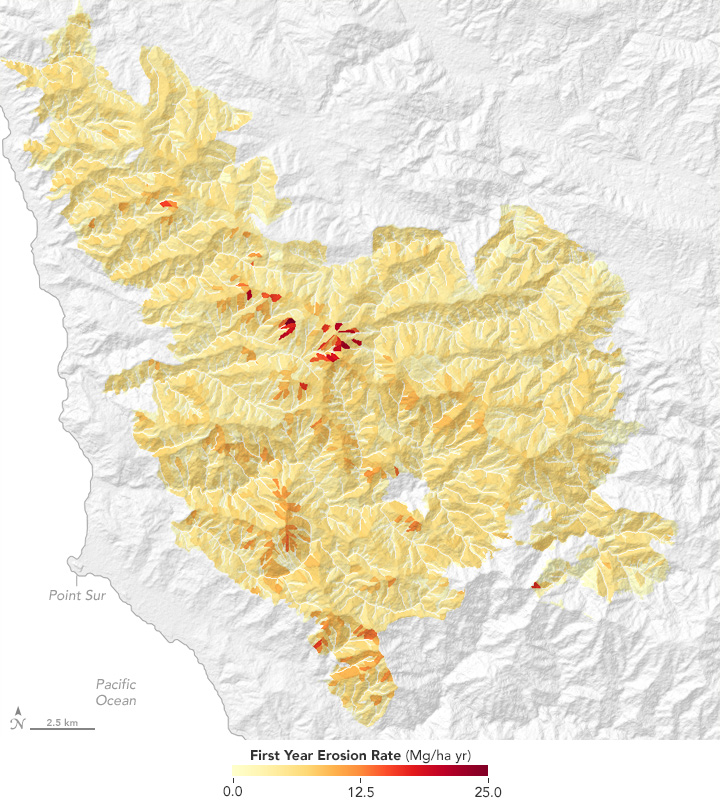
The image above shows one type of map produced from data delivered by the Rapid Response Erosion Database. It depicts likely erosion rates for the first year in the burned area of the Soberanes fire. Redder areas are more likely to experience the highest erosion rates. Generally, areas with higher erosion rates are associated with steeper terrain and with places where the ground was more severely burned.
“We chose to create hillslope-scale erosion maps, as they help BAER teams prioritize mulch treatments,” Miller said. Response teams also use the database to create spatial maps of runoff. After a fire, storm water runoff has the potential to overwhelm culverts along U.S. Forest Service roads. Maps of runoff can help response teams predict whether culverts can handle peak water flows.
NASA Earth Observatory map by Jesse Allen based on data from Mary Ellen Miller/Michigan Tech Research Institute, the Rapid Response Erosion Database (RRED), and the Water Erosion Prediction Project (WEPP). Story by Kathryn Hansen.