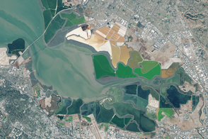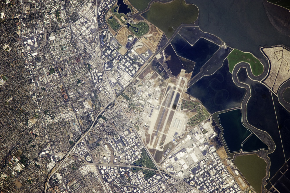
This astronaut photograph illustrates the diverse built environment surrounding the NASA Ames Research Center located at the southernmost end of San Francisco Bay. Founded in 1939 as an aircraft research laboratory, Ames became a NASA facility in 1958. Its original aircraft research focus was enhanced by the adjacent Moffett Field—an active Naval Air Station until 1994, and the original home of the Navy dirigible U.S.S. Macon. The large hanger for docking the U.S.S. Macon is still present at Moffett Field, and is visible in this astronaut photograph (image center). Today, NASA Ames includes the former Naval Air Station, and it continues its focus on aeronautics in addition to nanotechnology, information technology, fundamental space biology, biotechnology, thermal protection systems, and human factors research.
Land use and land cover in the southern San Francisco Bay area is a diverse mix of industrial, institutional, and residential patterns. Industrial lots, characterized by lack of green vegetation and large buildings with highly reflective white rooftops, border NASA Ames to the west, east, and south. The city of Mountain View directly to the south appears as a dense gray-brown network of streets and residential properties with interspersed green parks. The northern boundary of NASA ARC consists of former salt ponds that are being restored to tidal wetlands (image right). Drainage channels that predate the salt pond levees are visible at image right.
Astronaut photograph ISS017-E-6184 was acquired May 3, 2008, with a Nikon D2Xs digital camera using an 800 mm lens, and is provided by the ISS Crew Earth Observations experiment. The image was taken by the Expedition 17 crew, and is provided by the Image Science & Analysis Laboratory, Johnson Space Center. The image in this article has been cropped and enhanced to improve contrast. Lens artifacts have been removed. The International Space Station Program supports the laboratory to help astronauts take pictures of Earth that will be of the greatest value to scientists and the public, and to make those images freely available on the Internet. Additional images taken by astronauts and cosmonauts can be viewed at the NASA/JSC Gateway to Astronaut Photography of Earth. Caption by William L. Stefanov, NASA-JSC.